1
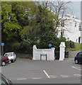
Walls, Coombe Vale Road, Teignmouth
The junction with Landscore Road, left, and Keatings Lane, right.
Straight ahead, a wall of rough Devonian limestone. Across the road, a wall of coarse New Red sandstone. It's a characteristic sight in this corner of Devon, where both rocks have been quarried.
Image: © Robin Stott
Taken: 19 May 2009
0.01 miles
2
Westbrook House, Westbrook Avenue, Teignmouth
Westbrook was one of the 'great houses' of West Teignmouth when it developed as a resort in the late eighteenth century. It was occupied by the builder William Bragg in 1811; Colonel Keating was the owner in 1854. Today it shows all the signs of being divided into flats.
Image: © Robin Stott
Taken: 6 Jul 2013
0.02 miles
3
Teignmouth
Coastal town and holiday resort on the Teign estuary - viewed here from the south west above Ringmore. Note the Shaldon-Teignmouth Bridge.
Image: © Colin Smith
Taken: 18 Jul 2021
0.02 miles
4
Westbrook Avenue, Teignmouth
Westbrook Avenue runs north to meet Keatings Lane.
Image: © Robin Stott
Taken: 6 Jul 2013
0.04 miles
5
South end of Reed Vale, Teignmouth
Bitton Park Road, once called Bitton Hill, is behind the camera.
Image: © Robin Stott
Taken: 6 Jul 2013
0.04 miles
6
Reed Vale, Teignmouth
Image: © Alex McGregor
Taken: 17 May 2011
0.04 miles
7
Westbrook Avenue, Teignmouth
No Through Road signs face Bitton Park Road at the southern end of Westbrook Avenue.
Image: © Jaggery
Taken: 21 Apr 2016
0.05 miles
8
Westbrook Avenue
Shown on the map as Keatings Lane, but the sign clearly says Westbrook Avenue. Keatings Lane, I believe, starts further up this road.
Image: © N Chadwick
Taken: 28 Dec 2017
0.05 miles
9
Looking down Keatings Lane to First Avenue
Keatings Lane drops steeply down from Coombe Vale Road
Image
Image: © Robin Stott
Taken: 14 Jul 2012
0.05 miles
10
Coombe Vale Rd
Image: © N Chadwick
Taken: 3 Jan 2013
0.05 miles


