IMAGES TAKEN NEAR TO
Higher Exeter Road, TEIGNMOUTH, TQ14 9PB
Introduction
This page details the photographs taken nearby to Higher Exeter Road, TQ14 9PB by members of the Geograph project.
The Geograph project started in 2005 with the aim of publishing, organising and preserving representative images for every square kilometre of Great Britain, Ireland and the Isle of Man.

There are currently over 7.5m images from over14,400 individuals and you can help contribute to the project by visiting https://www.geograph.org.uk
Image Map
Images are licensed for reuse under creativecommons.org/licenses/by-sa/2.0
Notes
- Clicking on the map will re-center to the selected point.
- The higher the marker number, the further away the image location is from the centre of the postcode.
Image Listing (29 Images Found)
Images are licensed for reuse under creativecommons.org/licenses/by-sa/2.0
Image
Details
Distance
1
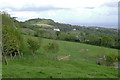
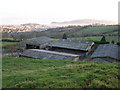
Sheep in a field, Hi Heather, Higher Exeter Road
The map says Hi Heather here, but a sign at the entrance says Teign View Farm, Pedigree Herd.
Another puzzle is the large white building, which does not seem to be shown on the map. On the skyline are the summit of Holcombe Down and the upper reaches of Teignmouth.
Image: © Robin Stott
Taken: 17 May 2009
0.12 miles
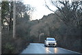
5
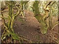
Bank on Holcombe Down
This bank runs along the side of the ridge through woodland, parallel to the lane.
Image: © Derek Harper
Taken: 13 Feb 2009
0.21 miles
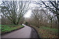
6
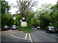
Sunday afternoon on the road, Holcombe Down
Holcombe Down Road, left, a back road to Dawlish, meets the fast, steep Higher Exeter Road coming up from Teignmouth.
Image: © Robin Stott
Taken: 17 May 2009
0.21 miles
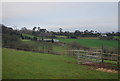
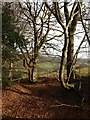
7
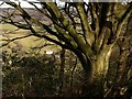
Beech above Lidwell Farm
The branches of this beech tree in Image frame a view of Lidwell Farm down in the southern arm of the Aller Brook valley.
Image: © Derek Harper
Taken: 13 Feb 2009
0.21 miles
8
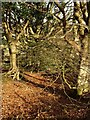
Woodland, Holcombe Down
Another view close to the scene in Image
Image: © Derek Harper
Taken: 13 Feb 2009
0.21 miles
9
Woodland, Holcombe Down
Beech trees at the edge of woodland on the upper slopes of the Aller Brook valley.
Image: © Derek Harper
Taken: 13 Feb 2009
0.21 miles