IMAGES TAKEN NEAR TO
Higher Holcombe Road, TEIGNMOUTH, TQ14 9NP
Introduction
This page details the photographs taken nearby to Higher Holcombe Road, TQ14 9NP by members of the Geograph project.
The Geograph project started in 2005 with the aim of publishing, organising and preserving representative images for every square kilometre of Great Britain, Ireland and the Isle of Man.

There are currently over 7.5m images from over14,400 individuals and you can help contribute to the project by visiting https://www.geograph.org.uk
Image Map (Loading...)


Getting Data...Please wait
Leaflet Map data © OpenStreetMap
Images are licensed for reuse under creativecommons.org/licenses/by-sa/2.0
Notes
- Clicking on the map will re-center to the selected point.
- The higher the marker number, the further away the image location is from the centre of the postcode.
Image Listing (45 Images Found)
Images are licensed for reuse under creativecommons.org/licenses/by-sa/2.0
Image
Details
Distance
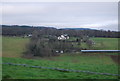
3
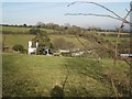
A glimpse of Higher Holcombe House, Teignmouth
Image: © Robin Stott
Taken: 11 Dec 2012
0.04 miles
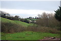
4
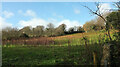
Field, Middle Holcombe
On the other side of Oak Hill Cross Road from Image
Image: © Derek Harper
Taken: 27 Dec 2020
0.12 miles
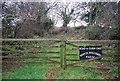
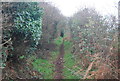
6
Farm track beside a footpath to Holcombe
Image: © David Smith
Taken: 14 Feb 2012
0.15 miles
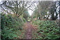
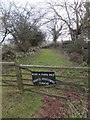
7
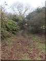
Footpath to Holcombe
The footpath follows field boundaries until it reaches the access track to Higher Holcombe Farm. Then it follows this overgrown (somewhat muddy) lane.
Image: © David Smith
Taken: 14 Feb 2012
0.16 miles
8
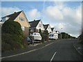
Higher Holcombe Drive, Teignmouth
This view is the reverse of Image
Image: © Robin Stott
Taken: 11 Dec 2012
0.16 miles