IMAGES TAKEN NEAR TO
Higher Holcombe Close, TEIGNMOUTH, TQ14 8RE
Introduction
This page details the photographs taken nearby to Higher Holcombe Close, TQ14 8RE by members of the Geograph project.
The Geograph project started in 2005 with the aim of publishing, organising and preserving representative images for every square kilometre of Great Britain, Ireland and the Isle of Man.

There are currently over 7.5m images from over14,400 individuals and you can help contribute to the project by visiting https://www.geograph.org.uk
Image Map (48 Images)


Getting Data...Please wait
Leaflet Map data © OpenStreetMap
Images are licensed for reuse under creativecommons.org/licenses/by-sa/2.0
Notes
- Clicking on the map will re-center to the selected point.
- The higher the marker number, the further away the image location is from the centre of the postcode.
Image Listing (48 Images Found)
Images are licensed for reuse under creativecommons.org/licenses/by-sa/2.0
Image
Details
Distance
1
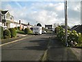
East on Higher Holcombe Close, Teignmouth
In these estates there are steep roads that cross the contours, and level roads that follow the contours. Higher Holcombe Close is one of the latter.
Image: © Robin Stott
Taken: 11 Dec 2012
0.02 miles
2
Higher Holcombe Drive, Teignmouth
This view is the reverse of Image
Image: © Robin Stott
Taken: 11 Dec 2012
0.07 miles
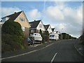
3
Junction of Higher Holcombe Drive and Higher Holcombe Road, Teignmouth
Teignmouth's high-altitude estates enjoy fine views, not just of the sea but, here, across to Holcombe Down and the edge of Little Haldon. This view is the reverse of Image
Image: © Robin Stott
Taken: 11 Dec 2012
0.08 miles
4
Putting a dormer on Christine?s salon, Higher Woodway Road, Teignmouth
Image: © Robin Stott
Taken: 11 Dec 2012
0.09 miles
5
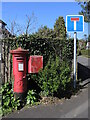
Moor Close letterbox
A George V version by Carron stands with a drop box a the end of the cul-de-sac.
Image: © Neil Owen
Taken: 30 Mar 2024
0.10 miles
6
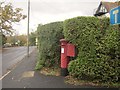
Postbox on New Road, Teignmouth
The George V postbox at the junction with Moor Close (right) is number TQ14 22.
Image: © Derek Harper
Taken: 15 Nov 2014
0.10 miles
7

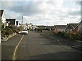
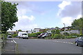
Woodway Road meets New Road, Teignmouth
A staggered crossroads, with Woodway Road continuing across on the left.
Image: © Derek Harper
Taken: 17 Sep 2022
0.11 miles
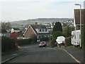
8
East on Higher Holcombe Road, Teignmouth
It is common on these hillside estates for two-storey houses on the upslope to look out over the roofs of their downslope neighbours whose houses are built into the hillside.
Image: © Robin Stott
Taken: 11 Dec 2012
0.12 miles
9
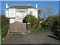
Sprey Point House, New Road, Teignmouth
This very tidy, all-white Victorian bay-fronted villa was neighbour to the few remaining open fields bordering New Road. Now they are being developed by Bovis as the Marine View estate. So, gradually, the houses creep up the hillsides towards Teignmouth's rural northern skyline. Sprey Point is the projection of the sea wall between Teignmouth and Holcombe http://www.geograph.org.uk/photo/3434944
Image: © Robin Stott
Taken: 10 Dec 2012
0.13 miles
10
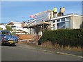
The fascias of Londis
A convenience store in Higher Woodway Road, just above the junction with Lyme Bay Road, left, and Higher Holcombe Road, right. Buses come up here too.
Image: © Robin Stott
Taken: 17 May 2009
0.13 miles