IMAGES TAKEN NEAR TO
Buckeridge Avenue, TEIGNMOUTH, TQ14 8LX
Introduction
This page details the photographs taken nearby to Buckeridge Avenue, TQ14 8LX by members of the Geograph project.
The Geograph project started in 2005 with the aim of publishing, organising and preserving representative images for every square kilometre of Great Britain, Ireland and the Isle of Man.

There are currently over 7.5m images from over14,400 individuals and you can help contribute to the project by visiting https://www.geograph.org.uk
Image Map (Loading...)


Getting Data...Please wait
Leaflet Map data © OpenStreetMap
Images are licensed for reuse under creativecommons.org/licenses/by-sa/2.0
Notes
- Clicking on the map will re-center to the selected point.
- The higher the marker number, the further away the image location is from the centre of the postcode.
Image Listing (87 Images Found)
Images are licensed for reuse under creativecommons.org/licenses/by-sa/2.0
Image
Details
Distance
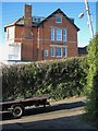
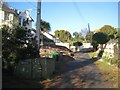
1

Buckeridge Avenue meets Buckeridge Road
Buckeridge Avenue, right, takes a civilised course along the contour while Buckeridge Road goes steeply straight up and down. The sea is now in view at the height.
Image: © Robin Stott
Taken: 6 May 2012
0.01 miles
2
Looking across Buckeridge Road from Trinity School
Above Trinity School and the last house in Glenside Close, opposite, Buckeridge Road narrows and steepens. In places it still has the character of a country lane.
Image: © Robin Stott
Taken: 10 Dec 2012
0.01 miles
3
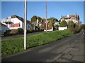
Glenside Close, a private road off Buckeridge Road
Private roads are a feature of Teignmouth's older suburbs. Glenside Close is relatively substantial; some private roads are more like shared drives, while at the other end of the spectrum they are grassy tracks.
Balconies enjoy sea views on these steep south-facing hillsides.
Image: © Robin Stott
Taken: 10 Dec 2012
0.03 miles
4
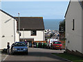
Looking down Trinity Close
A recent residential development off Grange Drive. The unexpected glimpse of the town through a gap emphasizes the height to which Teignmouth's new estates have climbed and are still climbing.
Image: © Robin Stott
Taken: 6 May 2012
0.04 miles
5
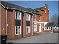
Trinity Lodge, pre-school nursery, Buckeridge Road
Sitting at angle to Buckeridge Road creates some parking space.
Image: © Robin Stott
Taken: 6 May 2012
0.05 miles
6
Elmonte Close, a private road off Buckeridge Road
Private roads are a feature of Teignmouth's older suburbs. Elmonte Close is no more than a shared drive; some private roads are more substantial while at the other end of the spectrum they are grassy tracks.
Image: © Robin Stott
Taken: 10 Dec 2012
0.06 miles
7
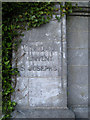
Pillar to flank wall, Trinity School entrance
Metal lettering discloses an earlier incarnation: Notre Dame Convent St Josephs.
Image: © Robin Stott
Taken: 6 May 2012
0.06 miles
8
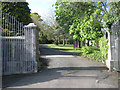
Gates of Trinity School, Buckeridge Road
Newish gates on old, Devonian limestone pillars. A pillar to the left carries the name Notre Dame Convent St Josephs Image
Image: © Robin Stott
Taken: 6 May 2012
0.06 miles
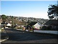
9
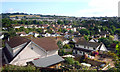
View of Part of Teignmouth
Just a general view of this residential part of town from an overlook beside the Exeter Road.
Image: © Des Blenkinsopp
Taken: 18 Jun 2011
0.07 miles
10
Looking east-northeast from the top of Hawkins Drive
Image: © Robin Stott
Taken: 10 Dec 2012
0.07 miles