IMAGES TAKEN NEAR TO
Clay Lane, TEIGNMOUTH, TQ14 8FW
Introduction
This page details the photographs taken nearby to Clay Lane, TQ14 8FW by members of the Geograph project.
The Geograph project started in 2005 with the aim of publishing, organising and preserving representative images for every square kilometre of Great Britain, Ireland and the Isle of Man.

There are currently over 7.5m images from over14,400 individuals and you can help contribute to the project by visiting https://www.geograph.org.uk
Image Map
Images are licensed for reuse under creativecommons.org/licenses/by-sa/2.0
Notes
- Clicking on the map will re-center to the selected point.
- The higher the marker number, the further away the image location is from the centre of the postcode.
Image Listing (937 Images Found)
Images are licensed for reuse under creativecommons.org/licenses/by-sa/2.0
Image
Details
Distance
1
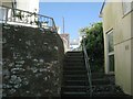
Steps up from Willow Street to Parson Street and Bitton Park Road, Teignmouth
This view is the near-reverse of Image
Image: © Robin Stott
Taken: 6 Jul 2013
0.00 miles
2
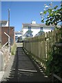
Footpath north from Willow Street past a clothes-drying area
On the right, brambles and bindweed are exploring space.
Image: © Robin Stott
Taken: 6 Jul 2013
0.00 miles
3
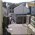
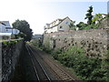
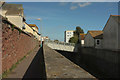
Willow Street footbridge over the railway, Teignmouth
The same view as Image but better-lit. Brunel's broad gauge railway was originally in a tunnel here (single track?) but (it is surmised) its replacement with double track at standard gauge around 1872 necessitated converting the tunnel to a cutting. This severed a number of streets; some were provided with footbridges or road bridges, some not, eg, Mulberry Street. The Willow Street footbridge is itself clearly a replacement for something older. Visibility is good so that pedestrians feel safe; precautions have been taken to deter climbers and would-be suicides.
Image: © Robin Stott
Taken: 6 Jul 2013
0.01 miles
4
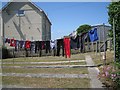
Washing lines, rear of Parson Street and Willow Street, Teignmouth
This is the drying area on the right in Image In the background are flats in Willow Street, left, and the back of Teignmouth telephone exchange, right.
Image: © Robin Stott
Taken: 6 Jul 2013
0.01 miles
5
The railway seen from Parson Street bridge
Looking westwards towards Newton Abbott.
Image: © Jonathan Thacker
Taken: 6 Sep 2014
0.01 miles
6
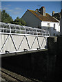
Willow Street footbridge over railway
Brunel's Great Western Railway went through the town in a deep cutting, severing a number of streets. The view from the lower end of the footbridge is Image and from the upper end Image
Image: © Robin Stott
Taken: 14 Sep 2011
0.01 miles
7
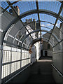
On Willow Street footbridge
An arch of mesh above the deck prevents anyone falling or dropping things from the bridge on to the railway. The view from the lower end is Image, and from the side Image
Image: © Robin Stott
Taken: 14 Sep 2011
0.01 miles
9
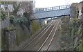
Railway footbridge, Teignmouth
From Clay Lane, emphasising how much the footbridge shown in Image] tilts up to the north.
Image: © Derek Harper
Taken: 28 Sep 2018
0.01 miles
10
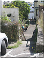
A glimpse of Mulberry Street
A fragment of old Teignmouth that may or may not be Mulberry Street.
The fabric of this part of the town has been disrupted by the nineteenth-century railway slicing through it, then World War II bombing and late twentieth-century road building and new residential development.
Image: © Robin Stott
Taken: 19 Aug 2012
0.01 miles