IMAGES TAKEN NEAR TO
Brunswick Street, TEIGNMOUTH, TQ14 8AE
Introduction
This page details the photographs taken nearby to Brunswick Street, TQ14 8AE by members of the Geograph project.
The Geograph project started in 2005 with the aim of publishing, organising and preserving representative images for every square kilometre of Great Britain, Ireland and the Isle of Man.

There are currently over 7.5m images from over14,400 individuals and you can help contribute to the project by visiting https://www.geograph.org.uk
Image Map (Loading...)


Getting Data...Please wait
Leaflet Map data © OpenStreetMap
Images are licensed for reuse under creativecommons.org/licenses/by-sa/2.0
Notes
- Clicking on the map will re-center to the selected point.
- The higher the marker number, the further away the image location is from the centre of the postcode.
Image Listing (1749 Images Found)
Images are licensed for reuse under creativecommons.org/licenses/by-sa/2.0
Image
Details
Distance
2
Vacant site off Brunswick Street, Teignmouth
There's reason to think that this site was a council depot, and that it is still owned either by Teignmouth Town Council or Teignbridge District Council – Teignmouth Urban District Council had its offices just along the road before they were bombed in World War II. The buildings in the photo front on to Northumberland Place.
Image: © Robin Stott
Taken: 11 May 2017
0.02 miles
3
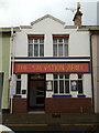
The New Quay Inn, Teignmouth
Rear bar entrance to this pub from Osmond's Lane.
Image: © Brian Clift
Taken: 16 Dec 2010
0.02 miles
4
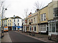
Bank Street, Teignmouth
December morning view in the direction of Den Road.
Image: © Brian Clift
Taken: 16 Dec 2010
0.02 miles
5
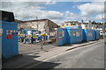
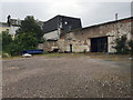
Contractor's compound, Brunswick Street
Interserve is the main contractor for the Teignmouth Tidal Flood Defence scheme, an Environment Agency project to prevent tidal surges flooding properties along and behind the river beach.
Image: © Robin Stott
Taken: 15 Jul 2012
0.02 miles
6
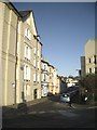
South end of Brunswick Street looking northwest from Den Crescent
Interesting that the buildings increase in height the nearer they are to the sea. South View, left, has five floors. Brunswick Street has been one-way north for a year or two – a great improvement.
Image: © Robin Stott
Taken: 10 Dec 2012
0.02 miles
7
Den Street, Teignmouth
View of its junction with Bank Street and Wellington Street.
Image: © Brian Clift
Taken: 16 Dec 2010
0.02 miles
8
Northumberland Place, Teignmouth
View in the direction of Osmond's Lane.
Image: © Brian Clift
Taken: 16 Dec 2010
0.02 miles
10
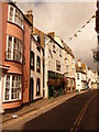
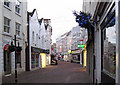
Teignmouth: Northumberland Place
Looking north along this attractive street in the town centre.
Image: © Chris Downer
Taken: 28 Aug 2009
0.02 miles