IMAGES TAKEN NEAR TO
Brook Lane, TEIGNMOUTH, TQ14 0AN
Introduction
This page details the photographs taken nearby to Brook Lane, TQ14 0AN by members of the Geograph project.
The Geograph project started in 2005 with the aim of publishing, organising and preserving representative images for every square kilometre of Great Britain, Ireland and the Isle of Man.

There are currently over 7.5m images from over14,400 individuals and you can help contribute to the project by visiting https://www.geograph.org.uk
Image Map (Loading...)


Getting Data...Please wait
Leaflet Map data © OpenStreetMap
Images are licensed for reuse under creativecommons.org/licenses/by-sa/2.0
Notes
- Clicking on the map will re-center to the selected point.
- The higher the marker number, the further away the image location is from the centre of the postcode.
Image Listing (193 Images Found)
Images are licensed for reuse under creativecommons.org/licenses/by-sa/2.0
Image
Details
Distance
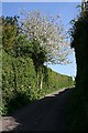
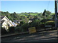
1
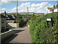
Looking down Brook Lane, Ringmore
Brook Lane climbs up from Ringmore Road Image and Image The slate roof on the left belongs to the building in Image
Image: © Robin Stott
Taken: 20 Aug 2012
0.01 miles
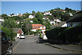
2
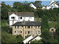
A block of flats in Ringmore?
This rather shabby three- or four-storey building on Brook Lane is in marked contrast to the well-maintained, white-painted neighbouring houses. Its roof is seen in Image
Image: © Robin Stott
Taken: 20 Aug 2012
0.01 miles
4
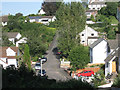
Laurel Lane, Ringmore
The east end of Laurel Lane, centre, is as steep or steeper than some roads in Teignmouth, for example: Image The flourishing poplar trees are a reminder that this is a brook valley.
Image: © Robin Stott
Taken: 20 Aug 2012
0.04 miles
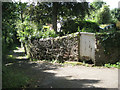
5
Peppery Lane
There are large detached houses hidden behind these high hedges.
Image: © Tony Atkin
Taken: 21 Apr 2009
0.04 miles
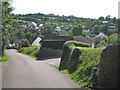
6
Orchard Close, Ringmore
Orchard Close drops down from Higher Ringmore Road, though not as dramatically as Laurel Lane Image Ringmore occupies the slopes of a steep brook valley.
Image: © Robin Stott
Taken: 20 Aug 2012
0.06 miles
7
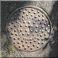
Sewer inspection cover, Salty Lane, Ringmore
Relief lettering states: F.PARKIN.BONHAY.FOUNDRY.EXETER.
Image: © Robin Stott
Taken: 20 Aug 2012
0.06 miles
8
East end of Brookvale Orchard, Ringmore
Brookvale Orchard is part lane, part footpath between Brook Lane and Higher Ringmore Road. The moss-covered blue-and-white object on the right is a small cabin cruiser.
Image: © Robin Stott
Taken: 20 Aug 2012
0.07 miles
9

Old Stoke House, Ringmore
Lovely pink and thatched cottage.
Image: © Maigheach-gheal
Taken: 18 Aug 2008
0.09 miles
10
View to Butterfly Lane from the west end of Laurel Lane, Ringmore
Butterfly Lane runs along the ridge that encloses the Ringmore valley. This is a view back down: Image
Image: © Robin Stott
Taken: 20 Aug 2012
0.09 miles