IMAGES TAKEN NEAR TO
Palk Close, TEIGNMOUTH, TQ14 0AH
Introduction
This page details the photographs taken nearby to Palk Close, TQ14 0AH by members of the Geograph project.
The Geograph project started in 2005 with the aim of publishing, organising and preserving representative images for every square kilometre of Great Britain, Ireland and the Isle of Man.

There are currently over 7.5m images from over14,400 individuals and you can help contribute to the project by visiting https://www.geograph.org.uk
Image Map (Loading...)


Getting Data...Please wait
Leaflet Map data © OpenStreetMap
Images are licensed for reuse under creativecommons.org/licenses/by-sa/2.0
Notes
- Clicking on the map will re-center to the selected point.
- The higher the marker number, the further away the image location is from the centre of the postcode.
Image Listing (211 Images Found)
Images are licensed for reuse under creativecommons.org/licenses/by-sa/2.0
Image
Details
Distance
1
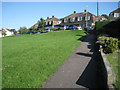
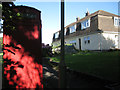
Houses and green, Palk Close
A footpath leads from Brook Lane to a green overlooked by former council houses. Not sure whether this is Ringmore or Shaldon.
Image: © Robin Stott
Taken: 20 Aug 2012
0.01 miles
2
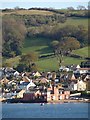
Ringmore Towers
The fort-like sandstone building jutting out into the Teign estuary is C19, but the turrets are later. Behind is housing where Ringmore and Shaldon meet, with the ground rising steeply towards The Beacon.
Image: © Derek Harper
Taken: 15 Apr 2008
0.02 miles
3
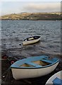
Boats at Ringmore
A few metres along Ringmore Road from Image
Image: © Derek Harper
Taken: 13 Feb 2009
0.02 miles
4

Sea Mist
Looking east towards Shaldon bridge which was shrouded in sea mist. This photo taken from the slipway at the end of The Strand at Newfoundland Point. So called because this was where the sailing ships used to anchor. The town of Shaldon grew from a fishing port associated with the Newfoundland cod industry to a fashionable resort of some note in Georgian times. In 1690, it was the last place in England to be invaded by a foreign power.
Image: © Anthony Volante
Taken: 23 Apr 2008
0.02 miles
5

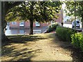
Green, Ringmore
This sloping green in front of Palk Close gives a view over the Teign estuary, even though it is partly obscured by the trees along the side of Ringmore Road.
Image: © Derek Harper
Taken: 1 Apr 2011
0.03 miles
6
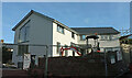
New house, Brook Lane, Ringmore
Seen on the right of Image
Image: © Derek Harper
Taken: 15 Dec 2020
0.03 miles
7

Green, Ringmore
Another view of the green shown in Image, with leaves on the line of trees showing an autumnal hue.
Image: © Derek Harper
Taken: 6 Nov 2011
0.03 miles
8
End house and phone box, Palk Close
A footpath leads from Brook Lane to a green overlooked by former council houses. Not sure whether this is Ringmore or Shaldon.
Image: © Robin Stott
Taken: 20 Aug 2012
0.03 miles
9
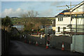
Brook Lane, Ringmore
With a new house on the right, and a view of the Teign estuary.
Image: © Derek Harper
Taken: 15 Dec 2020
0.04 miles
10
Keyworth Place, Ringmore
A reverse view of Image looking into the morning sunshine. Jutting out into the Teign estuary are Image
Image: © Derek Harper
Taken: 22 Sep 2009
0.04 miles