IMAGES TAKEN NEAR TO
St. Albans Road, TORQUAY, TQ1 3NF
Introduction
This page details the photographs taken nearby to St. Albans Road, TQ1 3NF by members of the Geograph project.
The Geograph project started in 2005 with the aim of publishing, organising and preserving representative images for every square kilometre of Great Britain, Ireland and the Isle of Man.

There are currently over 7.5m images from over14,400 individuals and you can help contribute to the project by visiting https://www.geograph.org.uk
Image Map
Images are licensed for reuse under creativecommons.org/licenses/by-sa/2.0
Notes
- Clicking on the map will re-center to the selected point.
- The higher the marker number, the further away the image location is from the centre of the postcode.
Image Listing (531 Images Found)
Images are licensed for reuse under creativecommons.org/licenses/by-sa/2.0
Image
Details
Distance
1
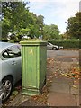
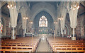
Lucy pillar, Babbacombe
A substantial pillar on St Anne's Road near its junction with St Alban's Road (background).
Image: © Derek Harper
Taken: 14 Oct 2014
0.01 miles
2
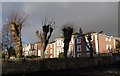
Pollarded trees, Babbacombe
These pollarded trees are alongside St Alban's Road, with a block of flats (right) and a care home on Palermo Road behind.
Image: © Derek Harper
Taken: 27 Dec 2009
0.02 miles
4
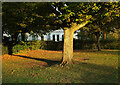
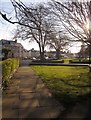
Cherry tree, Cary Park
At the eastern end of the path, with a house on St Alban's Road behind.
Image: © Derek Harper
Taken: 27 Oct 2020
0.03 miles
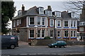
6
Cary Park
A triangle of grass at the junction of Car Avenue and St Alban's Road, cutting across the image. Beyond is an area of park between St Anne's Road (where the vehicles are parked) and All Saints' Church, which is just off to the right.
Image: © Derek Harper
Taken: 3 Apr 2013
0.03 miles
7
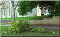
Fallen bough by All Saints, Babbacombe
Relatively minor damage from Storm Eunice earlier in the day, although obviously very dangerous if you happened to be passing at the wrong moment. The scar on the tree is just right of the cross on the grade I listed church, shown at https://www.geograph.org.uk/search.php?i=152278786 .
Image: © Derek Harper
Taken: 18 Feb 2022
0.04 miles
8

Palermo Road sign
The old blue and white tiles the pointing hand are at the eastern end, by the junction with St Alban's Road.
Image: © Derek Harper
Taken: 18 Feb 2022
0.04 miles
9
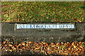
St Alban's Road, Babbacombe
The blue and white tiles are a familiar sight in Torquay.
Image: © Derek Harper
Taken: 22 Sep 2021
0.04 miles
10
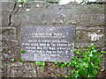
Coronation Park, Babbacombe, Glebe Land Notice
The park land to the north side of All Saints Church was Church of England Glebe Land until the 1990s. The main path was named Coronation Walk on 19th November 1952, by the Mayor of Torquay, Alderman T.J. Reeves Taylor. On the corner of the wall by the church is a plaque stating: Coronation Park. Notice is hereby given that this Glebe Land of the Church of England has not been dedicated to the public and no right of way exists over it. The park is bordered by St. Albans Road, St Anne's Road, Redenhill Road and Cary Avenue.
Image: © John C
Taken: 30 Oct 2015
0.04 miles