IMAGES TAKEN NEAR TO
Manaton, NEWTON ABBOT, TQ13 9XQ
Introduction
This page details the photographs taken nearby to TQ13 9XQ by members of the Geograph project.
The Geograph project started in 2005 with the aim of publishing, organising and preserving representative images for every square kilometre of Great Britain, Ireland and the Isle of Man.

There are currently over 7.5m images from over14,400 individuals and you can help contribute to the project by visiting https://www.geograph.org.uk
Image Map
Images are licensed for reuse under creativecommons.org/licenses/by-sa/2.0
Notes
- Clicking on the map will re-center to the selected point.
- The higher the marker number, the further away the image location is from the centre of the postcode.
Image Listing (32 Images Found)
Images are licensed for reuse under creativecommons.org/licenses/by-sa/2.0
Image
Details
Distance
1
Advisory speed limit on Dartmoor
40 MPH possible but not advisable with sheep ponies and walkers in the locality.
Other signs advise drivers to drive with Moor Care.
Image: © Anthony Vosper
Taken: 5 May 2019
0.02 miles
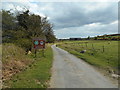
2

Lane to Hayne Down
Puddles on the lane north from Swallerton Gate, with browned bracken on the verges. The walkers are approaching a gate across the road.
Image: © Derek Harper
Taken: 30 Oct 2012
0.03 miles
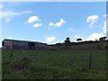
3
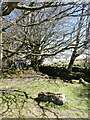
Granite trough at Moorhayes, near Hound Tor, Dartmoor
Image: © David Smith
Taken: 26 Apr 2021
0.04 miles
4
An action is required
A gated road on the approach to Bowerman's nose.
Which can just be seen on the horizon.
Image: © Anthony Vosper
Taken: 5 May 2019
0.04 miles
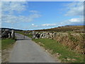
5

Gate onto Hayne Down
The lane from Swallerton Gate northwards is gated. You might imagine that the notice on this gate is a warning to shut it after passing through, but it actually prohibits climbing on Bowerman's Nose.
Image: © Derek Harper
Taken: 30 Oct 2012
0.06 miles
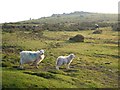
6

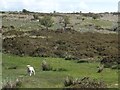
Lambs near Moorhayes
Young lambs on Swine Down by the lane shown in Image
Image: © Derek Harper
Taken: 30 Oct 2012
0.06 miles
7
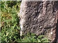
Benchmark on gatepost on Cripdon Down, Dartmoor
Ordnance Survey benchmark, described on database at https://www.bench-marks.org.uk/bm99469.
Image: © Becky Williamson
Taken: 9 Sep 2018
0.06 miles
9
Sheep on Cripdon Down
And rather more cattle among the gorse bushes. Bowerman's Nose is on the left horizon.
Image: © Derek Harper
Taken: 7 Jun 2006
0.10 miles