IMAGES TAKEN NEAR TO
Manaton, NEWTON ABBOT, TQ13 9XB
Introduction
This page details the photographs taken nearby to TQ13 9XB by members of the Geograph project.
The Geograph project started in 2005 with the aim of publishing, organising and preserving representative images for every square kilometre of Great Britain, Ireland and the Isle of Man.

There are currently over 7.5m images from over14,400 individuals and you can help contribute to the project by visiting https://www.geograph.org.uk
Image Map
Images are licensed for reuse under creativecommons.org/licenses/by-sa/2.0
Notes
- Clicking on the map will re-center to the selected point.
- The higher the marker number, the further away the image location is from the centre of the postcode.
Image Listing (11 Images Found)
Images are licensed for reuse under creativecommons.org/licenses/by-sa/2.0
Image
Details
Distance
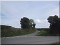
2
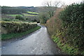
Access road to Easdon Farm
No through road; beyond the farm there is a public byway and path
Image: © David Smith
Taken: 6 Sep 2016
0.04 miles
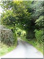
4
Field gate opposite lane to Easdon Farm
Image: © David Gearing
Taken: 30 May 2013
0.05 miles
5
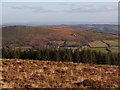
Easdon Down from Hamel Down
Looking across several squares, from close to Image Easdon Down is access land, but areas of gorse make it difficult to wander at will. Easdon Farm is in the centre, appearing above the conifers of Heathercombe Woods. The tiny white dot above the Down is Image
Image: © Derek Harper
Taken: 19 Nov 2006
0.09 miles
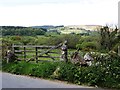
7
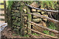
Slot - and - L gatepost
An old method of creating a barrier between posts.
Image: © Guy Wareham
Taken: 25 Dec 2012
0.11 miles
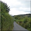
8
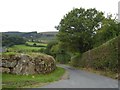
Access road to Vogwell Farm
Vogwell Farm is in the valley, west of the road
Image: © David Smith
Taken: 6 Sep 2016
0.11 miles
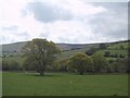
10
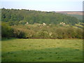
Vogwell Down
View from the lane between Heatree Cross and Watching Place Cross across the valley of one of the headwaters of the River Bovey to the wooded eastern slopes of Vogwell Down. In the right background are the woods around Heathercombe and Dartmoor proper near King's Tor.
Image: © Derek Harper
Taken: 7 Jun 2006
0.24 miles