IMAGES TAKEN NEAR TO
Lower Brookfield Terrace, NEWTON ABBOT, TQ13 9TP
Introduction
This page details the photographs taken nearby to Lower Brookfield Terrace, TQ13 9TP by members of the Geograph project.
The Geograph project started in 2005 with the aim of publishing, organising and preserving representative images for every square kilometre of Great Britain, Ireland and the Isle of Man.

There are currently over 7.5m images from over14,400 individuals and you can help contribute to the project by visiting https://www.geograph.org.uk
Image Map
Images are licensed for reuse under creativecommons.org/licenses/by-sa/2.0
Notes
- Clicking on the map will re-center to the selected point.
- The higher the marker number, the further away the image location is from the centre of the postcode.
Image Listing (102 Images Found)
Images are licensed for reuse under creativecommons.org/licenses/by-sa/2.0
Image
Details
Distance
1
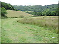
Trees along Wray Brook
Looking right from Image], with overlap. The footbridge carrying Lustleigh footpath 9 over the brook is on the left by the light upright post. The wood in the background is Tinhill Copse.
Image: © Derek Harper
Taken: 16 Mar 2020
0.05 miles
3
Wray Valley Trail approaching Lustleigh
Image: © David Smith
Taken: 15 Jul 2021
0.05 miles
4
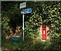
Postbox, Lustleigh
Victorian postbox TQ13 52 also appears in Image The Wray Valley Trail passes by.
Image: © Derek Harper
Taken: 9 Sep 2023
0.05 miles
5
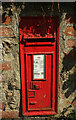
Postbox, Lustleigh
A close view of Victorian postbox TQ13 52 Image
Image: © Derek Harper
Taken: 9 Sep 2023
0.05 miles
6
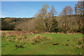
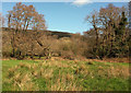
Path to Wray Brook
Lustleigh footpath 9 crosses a meadow to a footbridge, hidden on the right in the trees, over the stream. Greathill Copse is on the hillside in the background.
Image: © Derek Harper
Taken: 16 Mar 2020
0.06 miles
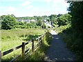
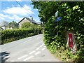
7
Wray Valley Trail at Lustleigh
Looking left from Image] towards the gates shown in Image Here the trail joins the road past Brookfield, Wreyland and Knowle for a couple of kilometres.
Image: © Derek Harper
Taken: 16 Mar 2020
0.06 miles
8
Lustleigh: Brookfield
The trees on the left rise up from a railway cutting, long disused, which took the branch line on towards Moretonhampstead
Image: © Martin Bodman
Taken: 6 Aug 2015
0.06 miles
9
Victorian wallbox in Knowle Road, Lustleigh
Image: © David Smith
Taken: 15 Jul 2021
0.06 miles
10
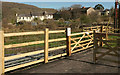
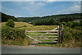
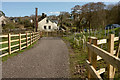
Gates on Wray Valley Trail
At the point where cyclists and pedestrians return to the roadway at Lustleigh. Those on foot have an additional option, that of going through the second gate onto Lustleigh footpath 9, which we have just followed. The houses are at Brookfield Cottages.
Image: © Derek Harper
Taken: 16 Mar 2020
0.06 miles