IMAGES TAKEN NEAR TO
Lustleigh, NEWTON ABBOT, TQ13 9TE
Introduction
This page details the photographs taken nearby to TQ13 9TE by members of the Geograph project.
The Geograph project started in 2005 with the aim of publishing, organising and preserving representative images for every square kilometre of Great Britain, Ireland and the Isle of Man.

There are currently over 7.5m images from over14,400 individuals and you can help contribute to the project by visiting https://www.geograph.org.uk
Image Map
Images are licensed for reuse under creativecommons.org/licenses/by-sa/2.0
Notes
- Clicking on the map will re-center to the selected point.
- The higher the marker number, the further away the image location is from the centre of the postcode.
Image Listing (223 Images Found)
Images are licensed for reuse under creativecommons.org/licenses/by-sa/2.0
Image
Details
Distance
1
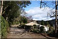
Lustleigh : Lane
A lane with Trapstile on the right.
Image: © Lewis Clarke
Taken: 21 Nov 2021
0.02 miles
2
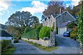
Road in Lustleigh
Lustleigh Footpath 1, after descending the charming Combe valley through a succession of fields, enters the village along this somewhat suburban road, with a mix of old and new properties.
Image: © Derek Harper
Taken: 14 Mar 2010
0.03 miles
3
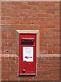
Lustleigh Post Office
The original Post Office has now closed, and is now used as a private residence. The new slimline version is across the road in another shop. The original Post Box has also had to be closed and a new one has been erected a few metres away, as the sign indicates.
Image: © Ian James Cox
Taken: 1 Jun 2009
0.03 miles
4

Lustleigh : Lane
A lane heads through the countryside.
Image: © Lewis Clarke
Taken: 21 Nov 2021
0.05 miles
5
Boulders in Town Orchard, Lustleigh
A reverse of the view in Image], with Lustleigh Footpath 35 heading towards the village. The stream shown in Image] is on the right; the May Queen Rock is beneath the conifer.
Image: © Derek Harper
Taken: 29 Nov 2012
0.05 miles
6
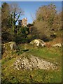
Boulders in Town Orchard, Lustleigh
Lustleigh Footpath 35 makes its way through a group of large granite boulders near the west end of the orchard. Underdown is the house above.
Image: © Derek Harper
Taken: 29 Nov 2012
0.05 miles
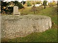
7
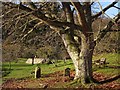
Lustleigh: by the May Queen Rock
Granite stone recording the names of Lustleigh's May Queen since 1954. A new throne for the queen stands atop the stone, hidden here by the tree. In the field which I think is known as Lustleigh Orchard and is a sort of public park with a public footpath running through it
Image: © Martin Bodman
Taken: 2 Jun 2011
0.05 miles
8
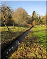
Stream, Lustleigh Orchard
Running towards the camera, this is a tributary of the Wray Brook. The prominent house overlooking the orchard is Underwood.
Image: © Derek Harper
Taken: 29 Nov 2012
0.05 miles
9
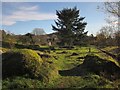
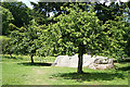
Lustleigh Orchard
The orchard, seen here from the east end, was given to the village in 1966. The May Day Rock can be seen.
Image: © Derek Harper
Taken: 29 Nov 2012
0.05 miles
10
May Day Rock, Lustleigh
In Town Orchard. Inscribed on the rock are the names of the May Queens crowned each May Day since 1954. Between 1905 (when the tradition was revived by Cecil Torr) and 1953, the ceremony was held at another rock above Wreyland. The throne dates from 2000, when it was cut from Blackingstone Quarry.
Image: © Derek Harper
Taken: 14 Dec 2008
0.05 miles