IMAGES TAKEN NEAR TO
Mill Road, NEWTON ABBOT, TQ13 9SS

Introduction

This page details the photographs taken nearby to Mill Road, TQ13 9SS by members of the Geograph project.

The Geograph project started in 2005 with the aim of publishing, organising and preserving representative images for every square kilometre of Great Britain, Ireland and the Isle of Man.

There are currently over 7.5m images from over14,400 individuals and you can help contribute to the project by visiting https://www.geograph.org.uk

Image Map


Images are licensed for reuse under creativecommons.org/licenses/by-sa/2.0
Notes
  • Clicking on the map will re-center to the selected point.
  • The higher the marker number, the further away the image location is from the centre of the postcode.

Image Listing (222 Images Found)

Images are licensed for reuse under creativecommons.org/licenses/by-sa/2.0
  • ...
Image
Details
Distance
1
Lustleigh Mill
Steps down to the former mill, which was served by Image - the accommodation description at http://www.dartmoormagazine.co.uk/index.php?option=com_content&view=section&layout=blog&id=11&Itemid=100&limitstart=8 suggests it still powers the electricity supply.
Image: © Derek Harper Taken: 25 Jul 2010
0.00 miles
2
Lustleigh Mill
Another view of Image partly hidden by fruit trees. In the background, and along the lane to Lustleigh, are Rock Cottages.
Image: © Derek Harper Taken: 25 Jul 2010
0.00 miles
3
Lustleigh : Mill House
Mill House and Mill Barn.
Image: © Lewis Clarke Taken: 21 Nov 2021
0.00 miles
4
Lane at Lustleigh Mill
The lane climbs steeply away from the mill, which is off to the left, past cottages.
Image: © Derek Harper Taken: 25 Jul 2010
0.01 miles
5
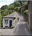
Lane past Lustleigh Mill
A reverse view down the hill shown in Image, with the mill cottages on the left, and some of the roofs of Lustleigh visible beyond.
Image: © Derek Harper Taken: 25 Jul 2010
0.01 miles
6
Lustleigh : Mill Lane
Looking along Mill Lane.
Image: © Lewis Clarke Taken: 21 Nov 2021
0.02 miles
7
Lustleigh : Railway Bridge
Looking down towards a disused railway bridge.
Image: © Lewis Clarke Taken: 21 Nov 2021
0.03 miles
8
Lustleigh : Railway Bridge
A disused railway bridge.
Image: © Lewis Clarke Taken: 21 Nov 2021
0.04 miles
9
Lane near Lustleigh Mill
This little lane winds along the west side of the valley of the Wray Brook.
Image: © Derek Harper Taken: 14 Mar 2010
0.04 miles
10
Lane at Lustleigh Mill
More of a reverse view of Image than Image
Image: © Derek Harper Taken: 7 Jul 2013
0.04 miles
  • ...