IMAGES TAKEN NEAR TO
Ilsington, NEWTON ABBOT, TQ13 9RU
Introduction
This page details the photographs taken nearby to TQ13 9RU by members of the Geograph project.
The Geograph project started in 2005 with the aim of publishing, organising and preserving representative images for every square kilometre of Great Britain, Ireland and the Isle of Man.

There are currently over 7.5m images from over14,400 individuals and you can help contribute to the project by visiting https://www.geograph.org.uk
Image Map
Images are licensed for reuse under creativecommons.org/licenses/by-sa/2.0
Notes
- Clicking on the map will re-center to the selected point.
- The higher the marker number, the further away the image location is from the centre of the postcode.
Image Listing (4 Images Found)
Images are licensed for reuse under creativecommons.org/licenses/by-sa/2.0
Image
Details
Distance
1
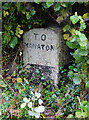
Old Guide Stone by Sigford Cross, Ilsington parish
Dartmoor granite guidepost by the UC road, in parish of Ilsington (Teignbridge District), Sigford Cross, by gate to "Cross Parks", under hedge.
Inscription reads:-
: TO / MANATON : : TO / ILSINGTON : : TO / ASHBURTON : : TO NEWTON :
Grade II listed.
List Entry Number: 1240581 https://historicengland.org.uk/listing/the-list/list-entry/1240581
Surveyed
Milestone Society National ID: DV_XILS06
Image: © Alan Rosevear
Taken: 10 Oct 2012
0.08 miles
2

Road sign at Cross Parks, near Ilsington
Image: © Ruth Sharville
Taken: 16 Jan 2017
0.08 miles
3

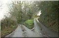
Road at Cross Parks, north of the cross roads, near Ilsington
Image: © Ruth Sharville
Taken: 16 Jan 2017
0.11 miles
4
Lane junction near Ilsington
Southwest of the village: left for Lounston, right for Sigford.
Image: © Derek Harper
Taken: 19 Jan 2023
0.19 miles