IMAGES TAKEN NEAR TO
Honeywill Lane, NEWTON ABBOT, TQ13 9RH
Introduction
This page details the photographs taken nearby to Honeywill Lane, TQ13 9RH by members of the Geograph project.
The Geograph project started in 2005 with the aim of publishing, organising and preserving representative images for every square kilometre of Great Britain, Ireland and the Isle of Man.

There are currently over 7.5m images from over14,400 individuals and you can help contribute to the project by visiting https://www.geograph.org.uk
Image Map
Images are licensed for reuse under creativecommons.org/licenses/by-sa/2.0
Notes
- Clicking on the map will re-center to the selected point.
- The higher the marker number, the further away the image location is from the centre of the postcode.
Image Listing (48 Images Found)
Images are licensed for reuse under creativecommons.org/licenses/by-sa/2.0
Image
Details
Distance
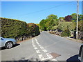
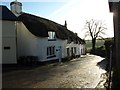
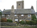
2
The centre of Ilsington
The smooth path across the cobbles provides wheelchair access through the gateway to the church. In the niche is a statue of St Michael, to whom the church is dedicated.
Image: © David Smith
Taken: 16 Apr 2012
0.06 miles
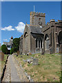
3
St Michael's Church, Ilsington
A view of the church looking across the allotments to the south.
Image: © Alan Hunt
Taken: 20 Jun 2010
0.07 miles
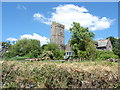
4
St Michael's Church
The southern aspect of this typical Dartmoor church, the very same church that I got married in all those years ago!
Image: © Alan Hunt
Taken: 20 Jun 2010
0.07 miles
5
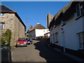
Ilsington
View NNW up the village street past thatched cottages to the church Image Simms Hill meets Old Town Hill.
Image: © Derek Harper
Taken: 4 Mar 2006
0.07 miles
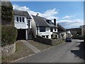
6
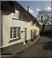
Simms Hill, Ilsington
Image: © Derek Harper
Taken: 9 Nov 2014
0.08 miles
8
Ilsington: St. Michael?s lychgate
A rather grand entranceway to Image
Image: © Chris Downer
Taken: 26 Aug 2009
0.08 miles
9
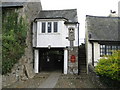
Ilsington: The west Lych Gate
The lych gate leads to Image, but was the scene of a near-tragedy on 17 September 1639. The room over the lych gate was in use as a school. A woman slammed the heavy oak gate causing the whole building to collapse. Four boys were thrown into the street, one into the churchyard, and others were buried in the rubble. Fortunately no boys were killed. The building was reconstructed in 1910.
Image: © Nigel Cox
Taken: 18 Oct 2008
0.08 miles
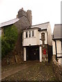
10
Ilsington: Former church house
With the tower of Image looming over it these are St Michael's Cottages, formerly the parish Church House. The left hand dwellings were subsequently used as the parish workhouse, but reputedly not used in such a capacity since about 1838, while the right hand dwelling was subsequently used as a brew house, and for a short time as the Church House Inn.
Image: © Nigel Cox
Taken: 18 Oct 2008
0.08 miles