IMAGES TAKEN NEAR TO
Tracey Vale, NEWTON ABBOT, TQ13 9EA
Introduction
This page details the photographs taken nearby to Tracey Vale, TQ13 9EA by members of the Geograph project.
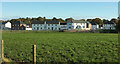
The Geograph project started in 2005 with the aim of publishing, organising and preserving representative images for every square kilometre of Great Britain, Ireland and the Isle of Man.

There are currently over 7.5m images from over14,400 individuals and you can help contribute to the project by visiting https://www.geograph.org.uk
Image Map
Images are licensed for reuse under creativecommons.org/licenses/by-sa/2.0
Notes
- Clicking on the map will re-center to the selected point.
- The higher the marker number, the further away the image location is from the centre of the postcode.
Image Listing (55 Images Found)
Images are licensed for reuse under creativecommons.org/licenses/by-sa/2.0
Image
Details
Distance
2
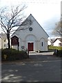
Catholic Church of the Holy Spirit, Bovey Tracey
Another photo in a different light of Image on Ashburton Road. To the left is The Presbytery. In the background on the right are houses on Avenue Road.
Image: © Derek Harper
Taken: 27 Jan 2013
0.07 miles
3
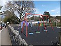
Children's playground beside the recreation ground
Image: © David Smith
Taken: 16 Apr 2012
0.08 miles
4
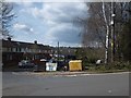
Brimley Vale
A housing development on the west of Bovey Tracey. The grit bin is needed as the slope leads to a bridge which becomes icy in winter.
Image: © David Smith
Taken: 16 Apr 2012
0.09 miles
5
Longston Cross
Looking right from Image] towards the main existing part of the recent housing development.
Image: © Derek Harper
Taken: 14 Nov 2021
0.10 miles
6
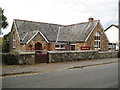
Bovey Tracey: Wickham Hall
The hall is on the west side of Ashburton Road opposite Image
Image: © Nigel Cox
Taken: 18 Oct 2008
0.10 miles
7
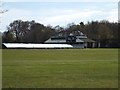
Bovey Tracey cricket ground and pavilion
Image: © David Smith
Taken: 16 Apr 2012
0.12 miles
8
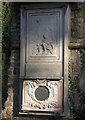
Memorial, Church of St John the Evangelist, Bovey Tracey
This memorial is at the foot of the west wall below Image It is to Hugh Beaufort, who died in 1915 in northern France. The circular plaque reads: " To the dear memory of Francis Hugh de Beaufort B A Christchurch Oxford Capn 2nd Bn Oxford & Bucks L I. Born July 27 1883. Fell near Richebourg L'Avoue Sunday Morning May 16 1915 RIP". An entry on http://thepeerage.com/p43606.htm#i436052 gives the date as 15th May, and the location as Festubert - in fact, the two villages are very close to one another, east of Bethune.
Image: © Derek Harper
Taken: 24 Oct 2010
0.12 miles
9
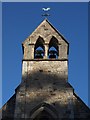
Bell turret, Church of St John the Evangelist, Bovey Tracey
The bellcote of Image: "gabled bell-turret; the latter has 2 bells
hung in a pair of open-pointed arches" http://www.britishlistedbuildings.co.uk/en-84478-church-of-st-john-the-evangelist-bovey-tr . Seen here from Ashburton Road.
Image: © Derek Harper
Taken: 24 Oct 2010
0.12 miles
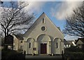
10
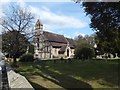
Anglican church of St John the Evangelist
Image: © David Smith
Taken: 16 Apr 2012
0.12 miles