IMAGES TAKEN NEAR TO
Cranley Gardens, NEWTON ABBOT, TQ13 8UT
Introduction
This page details the photographs taken nearby to Cranley Gardens, TQ13 8UT by members of the Geograph project.
The Geograph project started in 2005 with the aim of publishing, organising and preserving representative images for every square kilometre of Great Britain, Ireland and the Isle of Man.

There are currently over 7.5m images from over14,400 individuals and you can help contribute to the project by visiting https://www.geograph.org.uk
Image Map
Images are licensed for reuse under creativecommons.org/licenses/by-sa/2.0
Notes
- Clicking on the map will re-center to the selected point.
- The higher the marker number, the further away the image location is from the centre of the postcode.
Image Listing (197 Images Found)
Images are licensed for reuse under creativecommons.org/licenses/by-sa/2.0
Image
Details
Distance
1
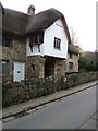
Chagford: The Bishop's House
Granite and thatch
Image: © Martin Bodman
Taken: 21 Nov 2017
0.03 miles
2
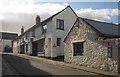
![Chagford houses [5]](https://s2.geograph.org.uk/geophotos/05/94/42/5944246_432b6f90_120x120.jpg)
Chagford houses [5]
Number 5 Southcombe Street is late 16th or early 17th century, a conversion of part of a hall house, the other part is now a separate dwelling, Orchard Cottage Image The house and the fine railings are listed, grade II, with details at: https://historicengland.org.uk/listing/the-list/list-entry/1106155
Image: © Michael Dibb
Taken: 26 Sep 2018
0.03 miles
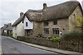
3
![Chagford houses [4]](https://s1.geograph.org.uk/geophotos/05/94/42/5944241_e6350af7_120x120.jpg)
Chagford houses [4]
Cranley House was built as a house in the mid 19th century. Later the left two rooms were converted into a shop and the building has been re-converted to a house. Listed, grade II, with details at: https://historicengland.org.uk/listing/the-list/list-entry/1308484
Image: © Michael Dibb
Taken: 26 Sep 2018
0.04 miles
4
![Chagford houses [6]](https://s0.geograph.org.uk/geophotos/05/94/42/5944248_76d15fe1_120x120.jpg)
Chagford houses [6]
The late 16th or early 17th century Orchard Cottage is part of a former hall house, the other part being number 5 Southcombe Street Image At one time a bakery with a massive chimney stack, the cottage is listed, grade II, with details at: https://historicengland.org.uk/listing/the-list/list-entry/1106154
Image: © Michael Dibb
Taken: 26 Sep 2018
0.04 miles
5
![Chagford houses [3]](https://s2.geograph.org.uk/geophotos/05/94/42/5944226_003f3eaa_120x120.jpg)
Chagford houses [3]
This 17th or 18th century property, Cobwebs, has been much altered and modernised circa 1980. Possibly originally two cottages. Listed, grade II, with details at: https://historicengland.org.uk/listing/the-list/list-entry/1106156
Image: © Michael Dibb
Taken: 26 Sep 2018
0.04 miles
6
The Bishop's House, Chagford
The Bishop's House in Lower Street was used by the Bishops of Exeter when they came to visit Chagford during the time that Chagford was a Stannary Town.
Image: © Alan Hunt
Taken: 18 Aug 2016
0.04 miles
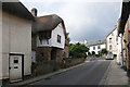
7
Southcombe Street joining the B3206, Chagford
Image: © Rob Purvis
Taken: 3 Sep 2009
0.04 miles
8
The Bishop's House, Chagford
This thatched house on Lower Street dates from the late 15th century and is one of the oldest in the town. It was reputedly used by the Bishop of Exeter when visiting the area. It is now grade II listed.
Image: © Stephen McKay
Taken: 21 Apr 2014
0.04 miles
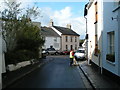
9
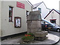
Water trough, Southcombe Street, Chagford
Wood and Rush, Basketmaker and local artisans
Image: © Rob Purvis
Taken: 3 Sep 2009
0.05 miles
10
North Street, Chagford
Shops in Chagford on the hill leading up to The Square.
Image: © Derek Harper
Taken: 17 Feb 2013
0.05 miles