IMAGES TAKEN NEAR TO
Doccombe, Moretonhampstead, NEWTON ABBOT, TQ13 8SX
Introduction
This page details the photographs taken nearby to TQ13 8SX by members of the Geograph project.
The Geograph project started in 2005 with the aim of publishing, organising and preserving representative images for every square kilometre of Great Britain, Ireland and the Isle of Man.

There are currently over 7.5m images from over14,400 individuals and you can help contribute to the project by visiting https://www.geograph.org.uk
Image Map
Images are licensed for reuse under creativecommons.org/licenses/by-sa/2.0
Notes
- Clicking on the map will re-center to the selected point.
- The higher the marker number, the further away the image location is from the centre of the postcode.
Image Listing (18 Images Found)
Images are licensed for reuse under creativecommons.org/licenses/by-sa/2.0
Image
Details
Distance
1
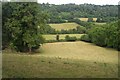
Devon field
Hilly woody country in the eastern foothills of Dartmoor.
Image: © Fiona Avis
Taken: Unknown
0.10 miles
2
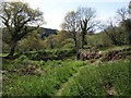
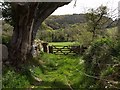
Bridleway near Leign
Moretonhampstead Bridleway 18 reaches the foot of a step descent below Woodcock Wood, turning sharp left at the gate to pass the scene in Image The track beyond the gate goes to the farm at Leign.
Image: © Derek Harper
Taken: 2 May 2009
0.13 miles
3
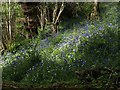
Bluebells in Woodcock Wood (3)
A little west of Image, and just below Moretonhampstead Bridleway 18 as it approaches the track between Leign and Upper Leign.
Image: © Derek Harper
Taken: 2 May 2009
0.14 miles
4
Bluebells in Woodcock Wood (2)
Looking back down Moretonhampstead Bridleway 18 past the bluebells shown in Image
Image: © Derek Harper
Taken: 2 May 2009
0.14 miles
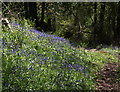
5
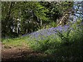
Bluebells in Woodcock Wood
Moretonhampstead Bridleway 18 passes drifts of bluebells close to the top of the steep climb.
Image: © Derek Harper
Taken: 2 May 2009
0.14 miles
6
Bridleway near Leign
Moretonhampstead Bridleway 18 at the western end of the walled section also shown in Image Through the gateway can be seen the valley below Doccombe.
Image: © Derek Harper
Taken: 2 May 2009
0.14 miles
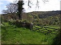
7
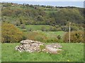
Doccombe valley
The valley below Doccombe, seen from Bridford Footpath 34 as it crosses the rock-strewn meadow seen in Image On the hilltop is Upper Leign, just into Image Woodcock Wood is on the right.
Image: © Derek Harper
Taken: 2 May 2009
0.16 miles
8
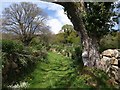
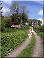
Bridleway to Leign
Moretonhampstead Bridleway 18 runs between what look like fairly recently-constructed walls as it climbs up the northern side of the Doccombe valley. Ahead is Woodcock Wood.
Image: © Derek Harper
Taken: 2 May 2009
0.16 miles
9
Gateway below Leign
Moretonhampstead Bridleway 18 reaches the end of the walled section and emerges into a field. A reverse view of Image
Image: © Derek Harper
Taken: 2 May 2009
0.17 miles
10
Bridleway near Leign
The bridleway passes Image as it climbs the track between Leign and Upper Leign.
Image: © Derek Harper
Taken: 2 May 2009
0.19 miles