IMAGES TAKEN NEAR TO
Moretonhampstead, NEWTON ABBOT, TQ13 8SR
Introduction
This page details the photographs taken nearby to TQ13 8SR by members of the Geograph project.
The Geograph project started in 2005 with the aim of publishing, organising and preserving representative images for every square kilometre of Great Britain, Ireland and the Isle of Man.

There are currently over 7.5m images from over14,400 individuals and you can help contribute to the project by visiting https://www.geograph.org.uk
Image Map
Images are licensed for reuse under creativecommons.org/licenses/by-sa/2.0
Notes
- Clicking on the map will re-center to the selected point.
- The higher the marker number, the further away the image location is from the centre of the postcode.
Image Listing (3 Images Found)
Images are licensed for reuse under creativecommons.org/licenses/by-sa/2.0
Image
Details
Distance
1
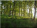
Cod Wood
Evening sun in oak woodland above the Teign valley.
Image: © Derek Harper
Taken: 7 Jun 2006
0.17 miles
2
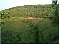
Re-entrant, Cod Wood
An embayment in the steep-sided Teign valley. Over twenty years earlier, on a walk while camping at Clifford Bridge, we emerged into this clearing to find it ablaze with foxgloves in flower. My young daughter commented that it was "all lovely and pink", at which point we discovered she was referring to her Wham Bar, purchased in the camp shop shortly before.
Image: © Derek Harper
Taken: 7 Jun 2006
0.18 miles
3
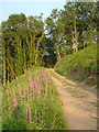
Track, Cod Wood
A track across the steep valley slope above the Teign approaches the edge of the clearing shown in Image
Image: © Derek Harper
Taken: 7 Jun 2006
0.24 miles