IMAGES TAKEN NEAR TO
Pepperdon Lane, NEWTON ABBOT, TQ13 8SL
Introduction
This page details the photographs taken nearby to Pepperdon Lane, TQ13 8SL by members of the Geograph project.
The Geograph project started in 2005 with the aim of publishing, organising and preserving representative images for every square kilometre of Great Britain, Ireland and the Isle of Man.

There are currently over 7.5m images from over14,400 individuals and you can help contribute to the project by visiting https://www.geograph.org.uk
Image Map
Images are licensed for reuse under creativecommons.org/licenses/by-sa/2.0
Notes
- Clicking on the map will re-center to the selected point.
- The higher the marker number, the further away the image location is from the centre of the postcode.
Image Listing (12 Images Found)
Images are licensed for reuse under creativecommons.org/licenses/by-sa/2.0
Image
Details
Distance
1
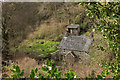
The Holt
A cottage on the tiny Pepperdon Hall Lane, here twisting round a pair of hairpins. Above is Steward Wood.
Image: © Derek Harper
Taken: 16 Mar 2020
0.00 miles
2
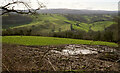
View from Pepperdon Down
From a gateway by the junction shown in Image
Image: © Derek Harper
Taken: 16 Mar 2020
0.09 miles
3
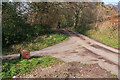
Junction, Pepperdon Down
Pepperdon Hall Lane drops tortuously to the left, while the lane around the edge of the down heads towards Cossick Cross.
Image: © Derek Harper
Taken: 16 Mar 2020
0.11 miles
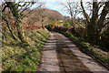
4
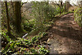
Pepperdon Hall Lane
Not recommended for motor vehicles. On the left is Moretonhampstead bridleway 24, which personally speaking I wouldn't recommend highly for horses or cyclists.
Image: © Derek Harper
Taken: 16 Mar 2020
0.13 miles
5
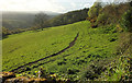
Field above Wray Cleave
Image: © Derek Harper
Taken: 25 Apr 2019
0.16 miles
6
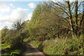
Lane by Pepperdon Down
The down, which is access land, climbs to the left.
Image: © Derek Harper
Taken: 16 Mar 2020
0.19 miles
7
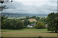
View from Pepperdon Down
Looking west with Pepperdon Farm in the foreground.
Image: © Guy Wareham
Taken: 4 Sep 2016
0.19 miles
8
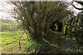
Bridleway below Pepperdon Hall Lane
Moretonhampstead bridleway 24 running through a tunnel of trees with a glimpse on the left of the Wray Brook and a tiny tributary flowing into it; beyond is the A382 and the tree-lined dismantled railway.
Image: © Derek Harper
Taken: 16 Mar 2020
0.19 miles
9
Lane past Pepperdon Down
The down (access land) is on the right. This looks in the opposite direction from where Image] was taken.
Image: © Derek Harper
Taken: 25 Apr 2019
0.22 miles
10

Bridleway below Pepperdon Hall Lane
Taken a little further down Moretonhampstead bridleway 24 from Image
Image: © Derek Harper
Taken: 16 Mar 2020
0.22 miles