IMAGES TAKEN NEAR TO
Moretonhampstead, NEWTON ABBOT, TQ13 8SE
Introduction
This page details the photographs taken nearby to TQ13 8SE by members of the Geograph project.
The Geograph project started in 2005 with the aim of publishing, organising and preserving representative images for every square kilometre of Great Britain, Ireland and the Isle of Man.

There are currently over 7.5m images from over14,400 individuals and you can help contribute to the project by visiting https://www.geograph.org.uk
Image Map
Images are licensed for reuse under creativecommons.org/licenses/by-sa/2.0
Notes
- Clicking on the map will re-center to the selected point.
- The higher the marker number, the further away the image location is from the centre of the postcode.
Image Listing (29 Images Found)
Images are licensed for reuse under creativecommons.org/licenses/by-sa/2.0
Image
Details
Distance
1
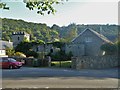
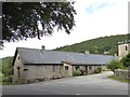
Wray Barton
Buildings at Grays Court, Wray Barton.
Image: © Michael Dibb
Taken: 27 Sep 2018
0.01 miles
2
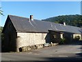
Barn conversion
This long rectangular barn, built in the late 19th century has been converted in living accommodation. Listed, grade II, with details at: https://historicengland.org.uk/listing/the-list/list-entry/1334196
Image: © Michael Dibb
Taken: 27 Sep 2018
0.02 miles
3
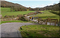
Wray Barton from the east
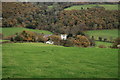
Looking down on the manor and converted farm buildings of Wray Barton from the footpath between the ruins of Lewdowns Cottages and Pepperdon Farm, with Wray Cleave wood in between on the steep hillside of the Wray Brook valley. Beyond, past Narramore Farm, the view covers the country north-east of Dartmoor.
Image: © Derek Harper
Taken: 29 May 2006
0.02 miles
5
Wray Valley Trail
The newly opened multi-use trail about to pass under a lane at Wray Barton.
Image: © Guy Wareham
Taken: 20 Mar 2020
0.04 miles
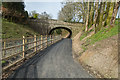
6
Once were trains
From the bridge carrying the minor road is the barest glimpse, through the trees, of the trackbed of the dismantled branch line from Newton Abbot to Moretonhampstead which, at this point, runs alongside the road.
Image: © Michael Dibb
Taken: 27 Sep 2018
0.04 miles
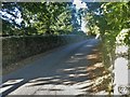
7
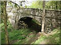
Bridge over dismantled railway at Wray Barton
Image: © David Gearing
Taken: 23 May 2013
0.04 miles
8
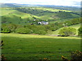
Wray Valley Trail at Wray Barton
From a track that links to the lane to Barne Cross. The new trail sticks closely to the line if the A382, while the embankment carrying the line of the dismantled Moretonhampstead and South Devon railway is on the right. The woods are Wray Cleave (left) and Huntingpark Wood (right). The line of trees left of centre follows the course of the Wray Brook.
Image: © Derek Harper
Taken: 16 Mar 2020
0.04 miles
9
Over the dismantled railway
From the A382 road, this minor road runs to Barne Cross. Here the bridge carries the road over the dismantled former branch line from Newton Abbot to Moretonhampstead which, at this point, runs alongside the road.
Image: © Michael Dibb
Taken: 27 Sep 2018
0.05 miles