IMAGES TAKEN NEAR TO
Moretonhampstead, NEWTON ABBOT, TQ13 8QJ
Introduction
This page details the photographs taken nearby to TQ13 8QJ by members of the Geograph project.
The Geograph project started in 2005 with the aim of publishing, organising and preserving representative images for every square kilometre of Great Britain, Ireland and the Isle of Man.

There are currently over 7.5m images from over14,400 individuals and you can help contribute to the project by visiting https://www.geograph.org.uk
Image Map
Images are licensed for reuse under creativecommons.org/licenses/by-sa/2.0
Notes
- Clicking on the map will re-center to the selected point.
- The higher the marker number, the further away the image location is from the centre of the postcode.
Image Listing (6 Images Found)
Images are licensed for reuse under creativecommons.org/licenses/by-sa/2.0
Image
Details
Distance
1
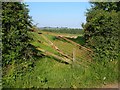
Custom-built gate, Greenawell
By the lane from Bughead Cross to Meacombe.
Image: © Derek Harper
Taken: 7 Jun 2006
0.16 miles
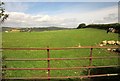
2
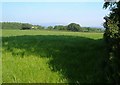
Grass field near Greenawell
A view over the gate shown in Image The wood behind the white barn is unnamed on the maps.
Image: © Derek Harper
Taken: 7 Jun 2006
0.16 miles
3
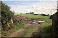
Field near Greenawell
On the other side of the lane from Image], with a pile of manure on the left. Across the field, left of centre and left of the trees, is a miniature tor, unnamed.
Image: © Derek Harper
Taken: 28 Aug 2014
0.18 miles
4
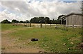
Barn and fence, Greenawell
Looking right from the same gateway as Image], with a barn and a gate through the fence for access.
Image: © Derek Harper
Taken: 28 Aug 2014
0.19 miles
5
Cattle near Greenawell
See Image]; this is the same field, indeed, on the left is the same cow.
Image: © Derek Harper
Taken: 28 Aug 2014
0.21 miles
6
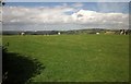
Cattle near Greenawell
From the lane from Bughead Cross to Drewston Cross, here at over 270 metres above sea level. The good view includes the shrouded Castle Drogo on the left. Image] shows the same field.
Image: © Derek Harper
Taken: 28 Aug 2014
0.23 miles