IMAGES TAKEN NEAR TO
Moretonhampstead, NEWTON ABBOT, TQ13 8QE
Introduction
This page details the photographs taken nearby to TQ13 8QE by members of the Geograph project.
The Geograph project started in 2005 with the aim of publishing, organising and preserving representative images for every square kilometre of Great Britain, Ireland and the Isle of Man.

There are currently over 7.5m images from over14,400 individuals and you can help contribute to the project by visiting https://www.geograph.org.uk
Image Map
Images are licensed for reuse under creativecommons.org/licenses/by-sa/2.0
Notes
- Clicking on the map will re-center to the selected point.
- The higher the marker number, the further away the image location is from the centre of the postcode.
Image Listing (5 Images Found)
Images are licensed for reuse under creativecommons.org/licenses/by-sa/2.0
Image
Details
Distance
1
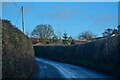
Moretonhampstead : A382
Looking along the A382.
Image: © Lewis Clarke
Taken: 9 Dec 2022
0.07 miles
2
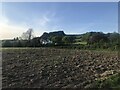
Lowton, Moretonhampstead
This is the western edge of Moretonhampstead.
Image: © Fiona Avis
Taken: 22 Oct 2005
0.07 miles
3
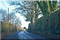
Moretonhampstead : A382
Heading along the A382.
Image: © Lewis Clarke
Taken: 9 Dec 2022
0.10 miles
4
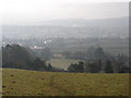
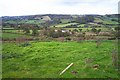
View south, from near Holcombe
Looking towards Dartmoor.
Image: © Roger Cornfoot
Taken: 10 Jan 2009
0.11 miles