IMAGES TAKEN NEAR TO
Moretonhampstead, NEWTON ABBOT, TQ13 8PT
Introduction
This page details the photographs taken nearby to TQ13 8PT by members of the Geograph project.
The Geograph project started in 2005 with the aim of publishing, organising and preserving representative images for every square kilometre of Great Britain, Ireland and the Isle of Man.

There are currently over 7.5m images from over14,400 individuals and you can help contribute to the project by visiting https://www.geograph.org.uk
Image Map
Images are licensed for reuse under creativecommons.org/licenses/by-sa/2.0
Notes
- Clicking on the map will re-center to the selected point.
- The higher the marker number, the further away the image location is from the centre of the postcode.
Image Listing (2 Images Found)
Images are licensed for reuse under creativecommons.org/licenses/by-sa/2.0
Image
Details
Distance
1
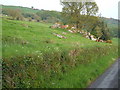
Rock outcrop near Uppacott
The calf is on a miniature tor beside the lane from Uppacott to Linscott. Behind, the lower slopes of Butterdon Down.
Image: © Derek Harper
Taken: 12 May 2006
0.10 miles
2
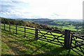
View from just above Uppacott - Chagford, Devon
The hills of Dartmoor on the horizon - Hey Tor and Hameldown.
Image: © Fiona Avis
Taken: 23 Oct 2005
0.15 miles