IMAGES TAKEN NEAR TO
Moretonhampstead, NEWTON ABBOT, TQ13 8PP
Introduction
This page details the photographs taken nearby to TQ13 8PP by members of the Geograph project.
The Geograph project started in 2005 with the aim of publishing, organising and preserving representative images for every square kilometre of Great Britain, Ireland and the Isle of Man.

There are currently over 7.5m images from over14,400 individuals and you can help contribute to the project by visiting https://www.geograph.org.uk
Image Map
Images are licensed for reuse under creativecommons.org/licenses/by-sa/2.0
Notes
- Clicking on the map will re-center to the selected point.
- The higher the marker number, the further away the image location is from the centre of the postcode.
Image Listing (4 Images Found)
Images are licensed for reuse under creativecommons.org/licenses/by-sa/2.0
Image
Details
Distance
1
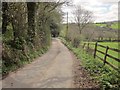
Lane from Howton
Image: © Derek Harper
Taken: 9 Apr 2014
0.19 miles
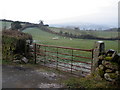
3
Sheep and bull pasture below Howton
With the lane on the right that's shown further down the hill in Image This is the gate from which Image was taken, hence the reference to the bull.
Image: © Derek Harper
Taken: 9 Apr 2014
0.22 miles
4
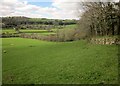
Countryside west of Moretonhampstead
See Image]; this looks more to the right from a few metres further down the lane.
Image: © Derek Harper
Taken: 9 Apr 2014
0.24 miles