IMAGES TAKEN NEAR TO
Lime Street, NEWTON ABBOT, TQ13 8LT
Introduction
This page details the photographs taken nearby to Lime Street, TQ13 8LT by members of the Geograph project.
The Geograph project started in 2005 with the aim of publishing, organising and preserving representative images for every square kilometre of Great Britain, Ireland and the Isle of Man.

There are currently over 7.5m images from over14,400 individuals and you can help contribute to the project by visiting https://www.geograph.org.uk
Image Map
Images are licensed for reuse under creativecommons.org/licenses/by-sa/2.0
Notes
- Clicking on the map will re-center to the selected point.
- The higher the marker number, the further away the image location is from the centre of the postcode.
Image Listing (285 Images Found)
Images are licensed for reuse under creativecommons.org/licenses/by-sa/2.0
Image
Details
Distance
1
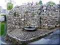
Wheelwright's form
Seen in Lime Street, the form was used in a nearby forge until the 1950s.
Image: © Michael Dibb
Taken: 24 Sep 2018
0.00 miles
2
![Moretonhampstead houses [12]](https://s0.geograph.org.uk/geophotos/05/93/37/5933704_afbfc944_120x120.jpg)
Moretonhampstead houses [12]
Dolphin House was formerly the Dolphin Inn. Probably 18th century incorporating some earlier fabric. The building was repaired and remodelled after a fire in 1816. Listed, grade II, with details at: https://historicengland.org.uk/listing/the-list/list-entry/1334225
Image: © Michael Dibb
Taken: 24 Sep 2018
0.00 miles
3
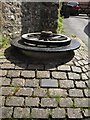
Wheelwright's form, Moretonhampstead
The plaque explains that the form was used in the Lime Street forge (a nearby building) until the 1950s. A passer-by told me that someone once tried to sell it, but it was recovered. It was placed here in 1983.
Image: © Derek Harper
Taken: 2 May 2009
0.01 miles
4
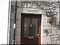
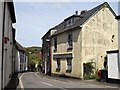
Old Police Station Moretonhampstead
First and last letters obliterated (probably by the Police authorities) to indicate it was no longer in use.
Image: © David M Jones
Taken: 29 Jul 2008
0.01 miles
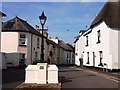
6
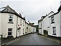
Moretonhampstead - Lime Street
Residential street in downtown Moretonhampstead.
www.visitmoretonhampstead.co.uk
Image: © Colin Smith
Taken: 30 Jul 2021
0.01 miles
8
![Moretonhampstead houses [13]](https://s1.geograph.org.uk/geophotos/05/93/37/5933705_50a447b5_120x120.jpg)
Moretonhampstead houses [13]
Number 9 Lime Street, built in the late 18th century has a timber framed upper part and has a virtually unalter front. Listed, grade II, with details at: https://historicengland.org.uk/listing/the-list/list-entry/1147834
Image: © Michael Dibb
Taken: 24 Sep 2018
0.01 miles
9
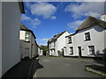
Lime Street, Moretonhampstead
The street turns the corner and drops sharply to the Wray Brook as it leaves the town.
Image: © Derek Harper
Taken: 2 May 2009
0.01 miles
10
![Moretonhampstead houses [11]](https://s2.geograph.org.uk/geophotos/05/93/36/5933698_e990188b_120x120.jpg)
Moretonhampstead houses [11]
Geneva Cottage, set at right angles to Lime Street is 18th century probably with some earlier fabric incorporated. One of the few thatched buildings to survicve in the centre of the town. Listed, grade II, with details at: https://historicengland.org.uk/listing/the-list/list-entry/1308361
Image: © Michael Dibb
Taken: 24 Sep 2018
0.01 miles