IMAGES TAKEN NEAR TO
Chagford, NEWTON ABBOT, TQ13 8JU
Introduction
This page details the photographs taken nearby to TQ13 8JU by members of the Geograph project.
The Geograph project started in 2005 with the aim of publishing, organising and preserving representative images for every square kilometre of Great Britain, Ireland and the Isle of Man.

There are currently over 7.5m images from over14,400 individuals and you can help contribute to the project by visiting https://www.geograph.org.uk
Image Map
Images are licensed for reuse under creativecommons.org/licenses/by-sa/2.0
Notes
- Clicking on the map will re-center to the selected point.
- The higher the marker number, the further away the image location is from the centre of the postcode.
Image Listing (12 Images Found)
Images are licensed for reuse under creativecommons.org/licenses/by-sa/2.0
Image
Details
Distance
1
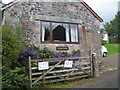
Stone Farm
The Mythic Garden sculpture garden is open from May to September
Image: © Rob Purvis
Taken: 31 Aug 2008
0.01 miles
2
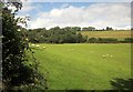
Sheep pasture near Stone Copse
Looking to the left from the same spot as Image], to the head of the valley.
Image: © Derek Harper
Taken: 28 Aug 2014
0.11 miles
3
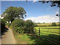
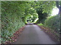
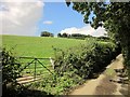
Lane to Stone Farm
Image: © Derek Harper
Taken: 28 Aug 2014
0.15 miles
4
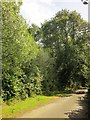
Lane past Parford Wood
From the same spot as Image], looking to the right down the lane towards Sandypark.
Image: © Derek Harper
Taken: 28 Aug 2014
0.16 miles
6
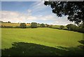
Field near Stone Copse
From the little lane that climbs from the A382 to Stone Farm, looking across the head of a small valley.
Image: © Derek Harper
Taken: 28 Aug 2014
0.17 miles
7
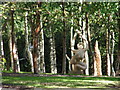
The Mythic Garden, Stone Farm
The sculptures are made by local (West Country) artists and are dotted around the gardens, amongst trees and sometimes under bushes, so it is quite fun trying to find all the sculptures listed in the catalogue.
Image: © Rob Purvis
Taken: 1 Aug 2004
0.18 miles
8
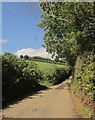
Lane past Stone Copse
The lane from which, 100 metres further up, Image] was taken.
Image: © Derek Harper
Taken: 28 Aug 2014
0.20 miles
9
Lane past Stone Copse
This gateway is just discernible in Image The right-angled bend in the field boundary up the steep hillside is in Image
Image: © Derek Harper
Taken: 28 Aug 2014
0.20 miles
10
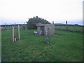
Cold War Bunker
A view looking to the southeast at the Drewsteignton Royal Observer Corps bunker, now de-commissioned.
Image: © Phil Williams
Taken: 24 Oct 2006
0.25 miles