IMAGES TAKEN NEAR TO
Chagford, NEWTON ABBOT, TQ13 8HX
Introduction
This page details the photographs taken nearby to TQ13 8HX by members of the Geograph project.
The Geograph project started in 2005 with the aim of publishing, organising and preserving representative images for every square kilometre of Great Britain, Ireland and the Isle of Man.

There are currently over 7.5m images from over14,400 individuals and you can help contribute to the project by visiting https://www.geograph.org.uk
Image Map
Images are licensed for reuse under creativecommons.org/licenses/by-sa/2.0
Notes
- Clicking on the map will re-center to the selected point.
- The higher the marker number, the further away the image location is from the centre of the postcode.
Image Listing (8 Images Found)
Images are licensed for reuse under creativecommons.org/licenses/by-sa/2.0
Image
Details
Distance
1
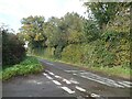
A mixture of plants forming a hedge at Waye Cross
Image: © David Smith
Taken: 23 Oct 2020
0.01 miles
3
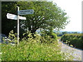
Signpost, Way Down
At the road junction at the southeast corner of the access land. I think that's a heap of gravel on the left.
Image: © Derek Harper
Taken: 8 Jun 2006
0.14 miles
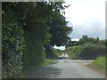
4
Way Down Cross
The fourth direction from this signpost is a footpath along a track
Image: © David Smith
Taken: 23 Oct 2020
0.14 miles
5
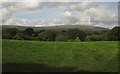
Towards Cosdon Hill
A view over a meadow and valley from near Monks Withecombe.
Image: © Derek Harper
Taken: 26 Aug 2012
0.18 miles
6
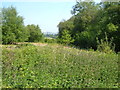
Way Down
The eastern side of the triangle of access land shown in Image, with a large patch of nettles.
Image: © Derek Harper
Taken: 8 Jun 2006
0.18 miles
7
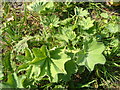
Lady's mantle, Way Down
A species of Alchemilla on the access land shown in Image
Image: © Derek Harper
Taken: 8 Jun 2006
0.18 miles
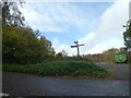
8
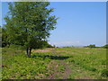
Way Down
A triangle of common land northwest of Chagford.
Image: © Derek Harper
Taken: 8 Jun 2006
0.19 miles