IMAGES TAKEN NEAR TO
Gidleigh, Chagford, NEWTON ABBOT, TQ13 8HR
Introduction
This page details the photographs taken nearby to TQ13 8HR by members of the Geograph project.
The Geograph project started in 2005 with the aim of publishing, organising and preserving representative images for every square kilometre of Great Britain, Ireland and the Isle of Man.

There are currently over 7.5m images from over14,400 individuals and you can help contribute to the project by visiting https://www.geograph.org.uk
Image Map
Images are licensed for reuse under creativecommons.org/licenses/by-sa/2.0
Notes
- Clicking on the map will re-center to the selected point.
- The higher the marker number, the further away the image location is from the centre of the postcode.
Image Listing (49 Images Found)
Images are licensed for reuse under creativecommons.org/licenses/by-sa/2.0
Image
Details
Distance
1

Gidleigh, Dartmoor
The main road through Gidleigh, a rural settlement in the Dartmoor National Park.
Image: © Alan Hunt
Taken: 18 Aug 2016
0.01 miles
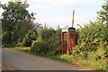
3

Byway, Gidleigh
The sign points down Gidleigh Byway 5; ahead, it is emerging from a tree-enclosed lane into the hamlet.
Image: © Derek Harper
Taken: 26 Aug 2012
0.03 miles
4
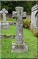
Old Wayside Cross - moved to Gidleigh churchyard
Greenway Cross, old head and shaft, Starkey No.97 by the churchyard path, in parish of Gidleigh (West Devon District), in church graveyard, Southeast of church, as gravestone for William Sampson (died 1940) of Greenway, was at Greenaway Farm.
Grade II listed.
List Entry Number: 1308387 https://historicengland.org.uk/listing/the-list/list-entry/1308387
Surveyed
Milestone Society National ID: DVWD_GID01
Image: © Alan Rosevear
Taken: 19 Oct 2012
0.04 miles
5
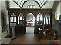
Gidleigh church
The churchyard is one of very few in England with a stream running through it. The stream (in shadow) separates the photographer from the building
Image: © David Smith
Taken: 13 Oct 2020
0.04 miles
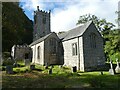
6
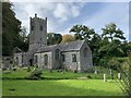
Holy Trinity Church, Gidleigh
The south side from the churchyard.
Image: © Andrew Abbott
Taken: 21 Sep 2019
0.04 miles
7

Ordnance Survey Cut Mark
This OS cut mark can be found on the west face of Holy Trinity Church. It marks a point 260.068m above mean sea level.
Image: © Adrian Dust
Taken: 29 Mar 2019
0.04 miles
9
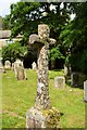
Cross, Gidleigh
In the churchyard of the Church of the Holy Trinity.
Image: © Derek Harper
Taken: 18 Jul 2017
0.04 miles