IMAGES TAKEN NEAR TO
Chagford, NEWTON ABBOT, TQ13 8HN
Introduction
This page details the photographs taken nearby to TQ13 8HN by members of the Geograph project.
The Geograph project started in 2005 with the aim of publishing, organising and preserving representative images for every square kilometre of Great Britain, Ireland and the Isle of Man.

There are currently over 7.5m images from over14,400 individuals and you can help contribute to the project by visiting https://www.geograph.org.uk
Image Map
Images are licensed for reuse under creativecommons.org/licenses/by-sa/2.0
Notes
- Clicking on the map will re-center to the selected point.
- The higher the marker number, the further away the image location is from the centre of the postcode.
Image Listing (4 Images Found)
Images are licensed for reuse under creativecommons.org/licenses/by-sa/2.0
Image
Details
Distance
1
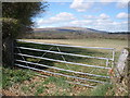
Access to Waye Farm
The entrance to the road is lined with substantial stone walls
Image: © David Smith
Taken: 3 Aug 2012
0.06 miles
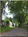
2
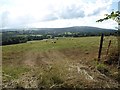
Grazing land opposite the entrance to Waye Farm
Cosdon Hill is on the distant horizon
Image: © David Gearing
Taken: 2 Aug 2013
0.08 miles
3
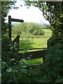
Footpath, Fox Hill Stile
South Tawton Footpath 33 sets out over a stile towards Thorn. The clumps of trees surrounded by a fenced-off area of meadow, mapped as Fox Hill Stile, looks like a small nature reserve.
Image: © Derek Harper
Taken: 8 Jun 2006
0.19 miles