IMAGES TAKEN NEAR TO
Chagford, NEWTON ABBOT, TQ13 8EW
Introduction
This page details the photographs taken nearby to TQ13 8EW by members of the Geograph project.
The Geograph project started in 2005 with the aim of publishing, organising and preserving representative images for every square kilometre of Great Britain, Ireland and the Isle of Man.

There are currently over 7.5m images from over14,400 individuals and you can help contribute to the project by visiting https://www.geograph.org.uk
Image Map
Images are licensed for reuse under creativecommons.org/licenses/by-sa/2.0
Notes
- Clicking on the map will re-center to the selected point.
- The higher the marker number, the further away the image location is from the centre of the postcode.
Image Listing (9 Images Found)
Images are licensed for reuse under creativecommons.org/licenses/by-sa/2.0
Image
Details
Distance
1
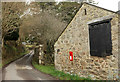
Barn and letterbox, Middlecott
This is at Middle Middlecot Farm (with one T on the maps). An adjoining linhay is listed; the description gives the farm two Ts. On the wall is a George VI letters only postbox, number TQ13 197.
Image: © Derek Harper
Taken: 6 Mar 2018
0.02 miles
2
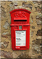
Letters only box, Middlecott
A close look at the George VI letters only postbox, number TQ13 197, shown in Image
Image: © Derek Harper
Taken: 6 Mar 2018
0.02 miles
3
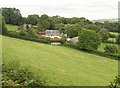
Middlecott
The nearest barn with the rusty red roof is the only building at the farm in this square; the rest are in Image This view is from Chagford Footpath 6.
Image: © Derek Harper
Taken: 27 Aug 2009
0.05 miles
4
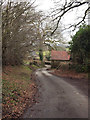
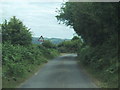
Lane at Middlecott
The lane from Week Down arrives at the hamlet; at right angles is a barn at Higher Middlecott Farm. Just beyond is the junction with the lane to Yellam.
Image: © Derek Harper
Taken: 6 Mar 2018
0.05 miles
5
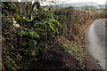
Old wall and scrubby field near Batworthy
Image: © David Smith
Taken: 4 Sep 2018
0.11 miles
6
Wall and hedge near Middlecott
The lane from Week Down. About four kilometres away is Easdon Down.
Image: © Derek Harper
Taken: 6 Mar 2018
0.21 miles
7
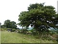
Week Down
Enclosed moorland crossed by Chagford Footpath 6. Parallel bands of bracken and gorse must indicate former field boundaries across this area.
Image: © Derek Harper
Taken: 27 Aug 2009
0.24 miles
9
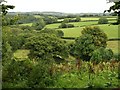
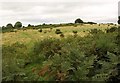
Countryside near Middlecott
Fields around the headwaters of a stream southeast of Middlecott, seen from Chagford Footpath 6.
Image: © Derek Harper
Taken: 27 Aug 2009
0.24 miles