IMAGES TAKEN NEAR TO
Chagford, NEWTON ABBOT, TQ13 8EN
Introduction
This page details the photographs taken nearby to TQ13 8EN by members of the Geograph project.
The Geograph project started in 2005 with the aim of publishing, organising and preserving representative images for every square kilometre of Great Britain, Ireland and the Isle of Man.

There are currently over 7.5m images from over14,400 individuals and you can help contribute to the project by visiting https://www.geograph.org.uk
Image Map
Images are licensed for reuse under creativecommons.org/licenses/by-sa/2.0
Notes
- Clicking on the map will re-center to the selected point.
- The higher the marker number, the further away the image location is from the centre of the postcode.
Image Listing (4 Images Found)
Images are licensed for reuse under creativecommons.org/licenses/by-sa/2.0
Image
Details
Distance
1
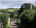
Batworthy
The lane from Stiniel leads between the C16 cow house (left - http://www.imagesofengland.org.uk/details/default.aspx?id=94532 ) and the C17 farmhouse http://www.imagesofengland.org.uk/Details/Default.aspx?id=94530&mode=adv .
Image: © Derek Harper
Taken: 27 Aug 2009
0.03 miles
2
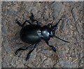
Bloody-nosed beetle, Batworthy
This looks like Timarcha tenebricosa making slow progress away from Batworthy along the tarmac of the lane.
Image: © Derek Harper
Taken: 27 Aug 2009
0.10 miles
3
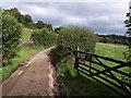
Lane near Batworthy
The lane east of Batworthy passes gates on either side as it begins a climb out of the Bovey valley.
Image: © Derek Harper
Taken: 27 Aug 2009
0.18 miles
4
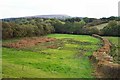
Fields near Batworthy - Devon
The upper reaches of the Bovey river are hidden by the trees.
Image: © Fiona Avis
Taken: 22 Oct 2005
0.21 miles