IMAGES TAKEN NEAR TO
Chagford, NEWTON ABBOT, TQ13 8EA
Introduction
This page details the photographs taken nearby to TQ13 8EA by members of the Geograph project.
The Geograph project started in 2005 with the aim of publishing, organising and preserving representative images for every square kilometre of Great Britain, Ireland and the Isle of Man.

There are currently over 7.5m images from over14,400 individuals and you can help contribute to the project by visiting https://www.geograph.org.uk
Image Map
Images are licensed for reuse under creativecommons.org/licenses/by-sa/2.0
Notes
- Clicking on the map will re-center to the selected point.
- The higher the marker number, the further away the image location is from the centre of the postcode.
Image Listing (33 Images Found)
Images are licensed for reuse under creativecommons.org/licenses/by-sa/2.0
Image
Details
Distance
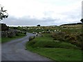
1
Trees by the moor at Metherall
The gate to Metherall is among the trees
Image: © David Smith
Taken: 3 Aug 2012
0.03 miles
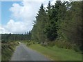
2
Road from Fernworthy towards Chagford
Image: © David Gearing
Taken: 25 Aug 2009
0.05 miles
3
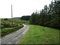
The road to Fernworthy Reservoir
The well defined boundary of the Fernworthy Forest plantation can be seen in the distance
Image: © David Gearing
Taken: 6 Aug 2012
0.16 miles
4
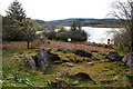
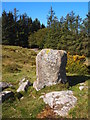
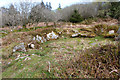
Bronze Age stone hut circle Fernworthy Reservoir
This ring of stones formed the base of a Bronze Age dwelling with a central pole forming the main support for a heather and thatch roof. The many stone hut circles at Fernworthy have been dated to the Beaker Folk who settled in this area around 2000BC. They are named after their characteristic pottery beakers, a waisted and decorated drinking vessel found across Western Europe during this period. The pots were also used for smelting, storing and preparing foodstuffs and as funerary urns. Apart from being early farmers and skilled archers, the Beaker Folk traded tin in the form of cassiterite pebbles found in streams throughout what is now Devon and Cornwall. Tin was used to turn copper into bronze from around 2200 BC and was widely traded throughout Britain and into Ireland, hence this period being called the Bronze Age.
Image: © Kate Jewell
Taken: 24 Apr 2014
0.16 miles
5
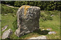
The Heath Stone
This is the stone marked on the OS map but it is not the original Heath Stone. This stone has a biblical inscription on one side inscribed in 1970.
Image: © Guy Wareham
Taken: 15 Jun 2009
0.17 miles
6
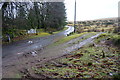
Minor road, Fernworthy Reservoir
The road around the Southern Shore of the reservoir heading Northeast towards Metherall and away from Fernworthy.
Image: © jeff collins
Taken: 28 Jan 2015
0.17 miles
7
Heath Stone, Metherall
Showing the biblical inscription added in 1970. This is unlikely to be the original way marker.
Image: © Chris Andrews
Taken: 18 Sep 2019
0.18 miles
9

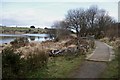
Moorland corner, Fernworthy
Taken from close to Image The road on the right leads into the nearby Image, at the edge of the extensive forest that surrounds the reservoir.
Image: © Derek Harper
Taken: 16 Nov 2009
0.18 miles
10
Bronze Age stone hut circle, Fernworthy Reservoir
This ring of stones formed the base of a Bronze Age dwelling with a central pole forming the main support for a heather and thatch roof. The many stone hut circles at Fernworthy have been dated to the Beaker Folk who settled in this area around 2000BC. They are named after their characteristic pottery beakers, a waisted and decorated drinking vessel found across Western Europe during this period. The pots were also used for smelting, storing and preparing foodstuffs and as funerary urns. Apart from being early farmers and skilled archers, the Beaker Folk traded tin in the form of cassiterite pebbles found in streams throughout what is now Devon and Cornwall. Tin was used to turn copper into bronze from around 2200 BC and was widely traded throughout Britain and into Ireland, hence this period being called the Bronze Age.
Image: © Kate Jewell
Taken: 24 Apr 2014
0.19 miles