IMAGES TAKEN NEAR TO
Widecombe-in-the-Moor, NEWTON ABBOT, TQ13 7TX
Introduction
This page details the photographs taken nearby to TQ13 7TX by members of the Geograph project.
The Geograph project started in 2005 with the aim of publishing, organising and preserving representative images for every square kilometre of Great Britain, Ireland and the Isle of Man.

There are currently over 7.5m images from over14,400 individuals and you can help contribute to the project by visiting https://www.geograph.org.uk
Image Map
Images are licensed for reuse under creativecommons.org/licenses/by-sa/2.0
Notes
- Clicking on the map will re-center to the selected point.
- The higher the marker number, the further away the image location is from the centre of the postcode.
Image Listing (10 Images Found)
Images are licensed for reuse under creativecommons.org/licenses/by-sa/2.0
Image
Details
Distance
1
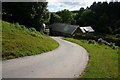
Broadaford
Looking back down the hill to the farm buildings.
Image: © jeff collins
Taken: 29 Jul 2015
0.01 miles
2
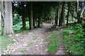
Track approaching Broadaford
This public access route starts close to East Shallowford passes through Broadaford and heads up to the minor road not far from Rowden.
Image: © jeff collins
Taken: 29 Jul 2015
0.05 miles
4

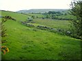
Broadaford Brook valley
This is the level meadow seen on the right of Image, taken from close to Image, again with Corndon Down rising on the horizon.
Image: © Derek Harper
Taken: 9 Jun 2006
0.17 miles
5
Broadaford Brook valley
Looking down the valley from the lane shown in Image, to where it joins the West Webburn a little beyond the confiders at Broadaford. Behind rises Corndon Down.
Image: © Derek Harper
Taken: 9 Jun 2006
0.18 miles
6
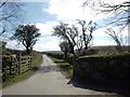
Bridge and Belted Galloways
The lane between Rowden and Cator crosses the Broadaford Brook, a tributary of the West Webburn. This herd of Belted Galloway seem to wander the lanes of east Dartmoor; they were in Image the previous week.
Image: © Derek Harper
Taken: 9 Jun 2006
0.22 miles
7
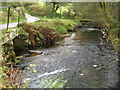
Dartmoor: West Webburn River
The West Webburn River is a tributary of the River Dart and is viewed here flowing downstream alongside the lane from Rowden Cross to Lower Cator.
Image: © Nigel Cox
Taken: 15 Oct 2008
0.23 miles
8
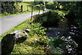
Small bridge
Carrying the minor road between Rowden Cross and Lower Cator over the West Webburn River.
Image: © jeff collins
Taken: 29 Jul 2015
0.23 miles
9
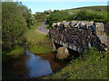
Dartmoor: Broadaford Brook bridge
Broadaford Brook is a tributary of the West Webburn River and is seen here about 500 metres upstream of its confluence with that river, being crossed by the bridge carrying the lane between Rowden Cross and Lower Cator. This is the same view of the same bridge as Derek's Image
Image: © Nigel Cox
Taken: 15 Oct 2008
0.24 miles
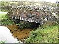
10

Bridge over Broadaford Brook
Another of the bridge shown in Image, showing the downstream side.
Image: © Derek Harper
Taken: 9 Jun 2006
0.24 miles