IMAGES TAKEN NEAR TO
Poundsgate, NEWTON ABBOT, TQ13 7PX
Introduction
This page details the photographs taken nearby to TQ13 7PX by members of the Geograph project.
The Geograph project started in 2005 with the aim of publishing, organising and preserving representative images for every square kilometre of Great Britain, Ireland and the Isle of Man.

There are currently over 7.5m images from over14,400 individuals and you can help contribute to the project by visiting https://www.geograph.org.uk
Image Map
Images are licensed for reuse under creativecommons.org/licenses/by-sa/2.0
Notes
- Clicking on the map will re-center to the selected point.
- The higher the marker number, the further away the image location is from the centre of the postcode.
Image Listing (45 Images Found)
Images are licensed for reuse under creativecommons.org/licenses/by-sa/2.0
Image
Details
Distance
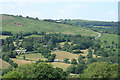
1
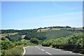
Newbridge Hill
View from Newbridge Hill into the Dart valley.
Image: © Bob Walters
Taken: 14 Jul 2022
0.05 miles
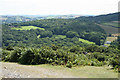
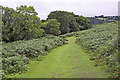
2
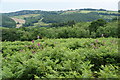
Healthy foliage in the Dart Valley
This is on the open land just above Hannaford.
Image: © Bill Boaden
Taken: 27 Jun 2011
0.11 miles
3
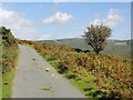
Road around Aish Tor
This very narrow road winds steeply uphill through Hannaford farm emerging on the side of Aish Tor with a great view to the north.
Image: © Tony Atkin
Taken: 11 Sep 2011
0.15 miles
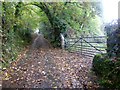
4
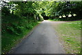
Minor road to Newbridge
Seen here at the top end of Newbridge Hill.
Image: © jeff collins
Taken: 18 Jun 2014
0.15 miles
5
Widecombe in the Moor: Hannaford
Seen from Green Down, Holne. The road to Dartmeet and Princetown via Poundsgate can be seen climbing the moor to the right
Image: © Martin Bodman
Taken: 27 Jun 2010
0.16 miles
6
Widecombe in the Moor: towards Holne Chase
On a track above Hannaford Manor, overlooking the wooded Dart valley near New Bridge. Ashburton lies in a valley beyond the woods
Image: © Martin Bodman
Taken: 21 Jul 2008
0.16 miles
7
Field gate near Hannaford
As is normal on the moor, the upright is a granite block
Image: © David Smith
Taken: 3 Nov 2015
0.16 miles
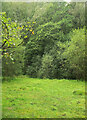
8
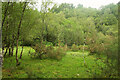
Newbridge Marsh
The linear stretch of marshland follows a former course of the River Dart west of its present course. See also Image
Image: © Derek Harper
Taken: 22 Aug 2021
0.17 miles
10
Newbridge Marsh
An area of wet meadow close to the car park at New Bridge. See also Image
Image: © Derek Harper
Taken: 22 Aug 2021
0.19 miles