IMAGES TAKEN NEAR TO
Poundsgate, NEWTON ABBOT, TQ13 7PU
Introduction
This page details the photographs taken nearby to TQ13 7PU by members of the Geograph project.
The Geograph project started in 2005 with the aim of publishing, organising and preserving representative images for every square kilometre of Great Britain, Ireland and the Isle of Man.

There are currently over 7.5m images from over14,400 individuals and you can help contribute to the project by visiting https://www.geograph.org.uk
Image Map
Images are licensed for reuse under creativecommons.org/licenses/by-sa/2.0
Notes
- Clicking on the map will re-center to the selected point.
- The higher the marker number, the further away the image location is from the centre of the postcode.
Image Listing (4 Images Found)
Images are licensed for reuse under creativecommons.org/licenses/by-sa/2.0
Image
Details
Distance
1
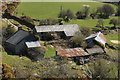
Rowbrook
Looking down on the farm buildings from the open moor to the west.
Image: © Guy Wareham
Taken: 9 Apr 2010
0.01 miles
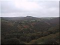
3

Dartmoor Forest: Sharp Tor
Seen from across the wooded Dart valley, from a point near Combestone Tor
Image: © Martin Bodman
Taken: 19 May 2011
0.24 miles
4
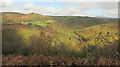
Dart valley from Holne Moor Leat
A similar view to Image] taken from the same spot as Image], with Luckey Tor in the centre at the bottom. Below Sharp Tor on the left is the farm at Rowbrook.
Image: © Derek Harper
Taken: 22 Oct 2020
0.24 miles