IMAGES TAKEN NEAR TO
Ashburton, NEWTON ABBOT, TQ13 7NW
Introduction
This page details the photographs taken nearby to TQ13 7NW by members of the Geograph project.
The Geograph project started in 2005 with the aim of publishing, organising and preserving representative images for every square kilometre of Great Britain, Ireland and the Isle of Man.

There are currently over 7.5m images from over14,400 individuals and you can help contribute to the project by visiting https://www.geograph.org.uk
Image Map
Images are licensed for reuse under creativecommons.org/licenses/by-sa/2.0
Notes
- Clicking on the map will re-center to the selected point.
- The higher the marker number, the further away the image location is from the centre of the postcode.
Image Listing (18 Images Found)
Images are licensed for reuse under creativecommons.org/licenses/by-sa/2.0
Image
Details
Distance
1
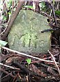
Old Milestone (Parole stone), West of Hele Cross
The milestone is located in front of the laurel hedge just west of the main entrance to Dart Vale, on the north side of the road. This area has now been cleared and the milestone re-sited, see https://www.geograph.org.uk/photo/7131804. Originally the milestone was located opposite the entrance to Dart Vale, on the south side of the road. Parish of Ashburton (Teignbridge District). Carved stone post, Ashburton Parole stone design, erected by the Government in the 18th century. (French prisoners of war on parole were stationed in Ashburton 1794-98 and were allowed to walk up to one mile from the town.)
Inscription reads:-
1 / Mile
Milestone Society National ID: DV_ASPS01B
Image: © Alan Rosevear
Taken: 14 Feb 2013
0.02 miles
2
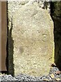
Old Milestone (Parole stone), West of Hele Cross
The milestone is now located in front of the main post of the side gate to the west of the main entrance to Dart Vale, on the north side of the road. Originally the milestone was located opposite the entrance to Dart Vale, on the south side of the road. Parish of Ashburton (Teignbridge District). Carved stone post, Ashburton Parole stone design, erected by the Government in the 18th century. (French prisoners of war on parole were stationed in Ashburton 1794-98 and were allowed to walk up to one mile from the town)
Inscription reads:-
1 / Mile
Milestone Society National ID: DV_ASPS01B
Image: © Tim Jenkinson
Taken: 12 Apr 2017
0.02 miles
4
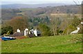
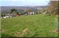
Adams Hele
A detail of the scene in Image], with the listed farmhouse https://www.historicengland.org.uk/listing/the-list/list-entry/1206377 , and a view to the Dart valley. In the centre are conifers at the River Dart Country Park.
Image: © Derek Harper
Taken: 12 Apr 2006
0.15 miles
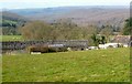
5
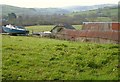
Adams Hele
A farm with listed farmhouse https://www.historicengland.org.uk/listing/the-list/list-entry/1206377 .
Image: © Derek Harper
Taken: 12 Apr 2006
0.16 miles
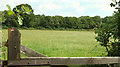
6
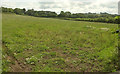
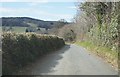
Grass field, Horsehill
Image: © Derek Harper
Taken: 31 Jul 2019
0.16 miles
7
Barns, Adams Hele
Some of the farm buildings shown in Image], plus the boat.
Image: © Derek Harper
Taken: 12 Apr 2006
0.18 miles
8
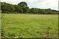
Grass field, Horsehill
A similar scene to Image] from a gate a little further along the road. Image] looks right; Image] looks across the road behind the camera.
Image: © Derek Harper
Taken: 31 Jul 2019
0.18 miles
9
Trees and field near Lent Hill
A clearer view over the second gate in Image], across a field to the roadside belts of trees beside the lane between Lent Hill and Hele Cross.
Image: © Derek Harper
Taken: 31 Jul 2019
0.18 miles
10
Barn, Adams Hele
Looking left from where Image] was taken, with a view to the wooded Dart valley.
Image: © Derek Harper
Taken: 12 Apr 2006
0.19 miles