IMAGES TAKEN NEAR TO
Ashburton, NEWTON ABBOT, TQ13 7NS
Introduction
This page details the photographs taken nearby to TQ13 7NS by members of the Geograph project.
The Geograph project started in 2005 with the aim of publishing, organising and preserving representative images for every square kilometre of Great Britain, Ireland and the Isle of Man.

There are currently over 7.5m images from over14,400 individuals and you can help contribute to the project by visiting https://www.geograph.org.uk
Image Map
Images are licensed for reuse under creativecommons.org/licenses/by-sa/2.0
Notes
- Clicking on the map will re-center to the selected point.
- The higher the marker number, the further away the image location is from the centre of the postcode.
Image Listing (5 Images Found)
Images are licensed for reuse under creativecommons.org/licenses/by-sa/2.0
Image
Details
Distance
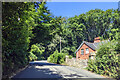
2
Road near Holne Chase
The road into Dartmoor starts a steep climb over the Holne Chase ridge on its way between Holne Old and New bridges.
Image: © Derek Harper
Taken: 17 Mar 2009
0.06 miles
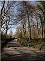
3
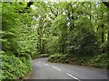
Holne Chase - Dartmoor
The Ashburton - Princetown road as it passes through the woods of Holne Chase beside the Dart valley.
Image: © Richard Knights
Taken: Unknown
0.13 miles
4
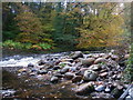
Granite Pebbles in the Dart
Colourful pebbles and autumn colours in the trees at the rapid known to canoeists as the "Spin Dryer". It gets its name from the eddy formed to the left of this picture which, in high water conditions, forms a powerful and fast circulation beside the main current.
Image: © Barry Deakin
Taken: 28 Oct 2009
0.20 miles
5
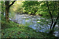
River Dart above Holne Bridge
A popular section of the river for canoeists who start from New Bridge and egress at Holne Bridge.
Image: © Guy Wareham
Taken: 8 Oct 2008
0.25 miles