IMAGES TAKEN NEAR TO
Waterleat Walk, Ashburton Park, NEWTON ABBOT, TQ13 7NL
Introduction
This page details the photographs taken nearby to Waterleat Walk, Ashburton Park, TQ13 7NL by members of the Geograph project.
The Geograph project started in 2005 with the aim of publishing, organising and preserving representative images for every square kilometre of Great Britain, Ireland and the Isle of Man.

There are currently over 7.5m images from over14,400 individuals and you can help contribute to the project by visiting https://www.geograph.org.uk
Image Map
Images are licensed for reuse under creativecommons.org/licenses/by-sa/2.0
Notes
- Clicking on the map will re-center to the selected point.
- The higher the marker number, the further away the image location is from the centre of the postcode.
Image Listing (17 Images Found)
Images are licensed for reuse under creativecommons.org/licenses/by-sa/2.0
Image
Details
Distance
1
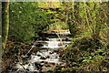
River Ashburn
The Ashburn flowing under the bridge near Waterleat Farm.
Image: © Guy Wareham
Taken: 25 Oct 2008
0.07 miles
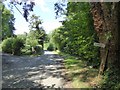
2
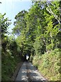
Road to Bowdley in Waterleat Wood
A steep climb out of the valley of the Ashburn
Image: © David Smith
Taken: 6 Aug 2014
0.07 miles
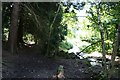
3
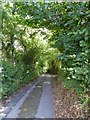
Minor road through Waterleat Wood
The road leads to farms and is a no through road, so is little used
Image: © David Smith
Taken: 6 Aug 2014
0.11 miles
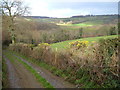
4
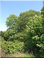
The edge of Waterleat Wood
Seen from the road from Lower Bowdley, woodland and a fringe of scrub
Image: © David Smith
Taken: 6 Aug 2014
0.12 miles
5
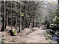
Woodland Footpath
Footpath beside the River Ashburn.
Image: © Tony Atkin
Taken: 6 Apr 2012
0.13 miles
6
Sign to Bowdley in Ashburn valley
The sign was damaged; only one finger has a sign, and the post has been uprooted
Image: © David Smith
Taken: 6 Aug 2014
0.14 miles
7
Dartmoor Way at Whiddon Wood
Looking west from the Way as it drops towards the River Ashburn. The buildings in the distance are at Bowdley in the next square west.
Image: © Derek Harper
Taken: 1 Apr 2006
0.15 miles
9
Woodland walk through Whiddon Scrubs
North of Ashburton
Image: © Duncan Grey
Taken: 3 Sep 2008
0.18 miles
10
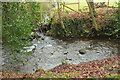
Stream joining the Ashburn
An unnamed stream from the Bowdley valley joins the river, seen from Ashburton footpath 3.
Image: © Derek Harper
Taken: 2 Jan 2021
0.18 miles