IMAGES TAKEN NEAR TO
Landscove, Ashburton, NEWTON ABBOT, TQ13 7LY
Introduction
This page details the photographs taken nearby to TQ13 7LY by members of the Geograph project.
The Geograph project started in 2005 with the aim of publishing, organising and preserving representative images for every square kilometre of Great Britain, Ireland and the Isle of Man.

There are currently over 7.5m images from over14,400 individuals and you can help contribute to the project by visiting https://www.geograph.org.uk
Image Map
Images are licensed for reuse under creativecommons.org/licenses/by-sa/2.0
Notes
- Clicking on the map will re-center to the selected point.
- The higher the marker number, the further away the image location is from the centre of the postcode.
Image Listing (54 Images Found)
Images are licensed for reuse under creativecommons.org/licenses/by-sa/2.0
Image
Details
Distance
1
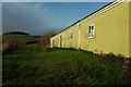
Primary School, Landscove
The western side of Landscove C of E Primary School. On the hilltop is Penn Plantation.
Image: © Derek Harper
Taken: 20 Dec 2020
0.01 miles
2
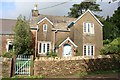
The School House, Landscove
The school itself is next door, to the left so the school house is between the church and the school.
Image: © Duncan Grey
Taken: 5 Sep 2008
0.02 miles
3
Primary School, Landscove
Behind rises the spire of Image
Image: © Derek Harper
Taken: 20 Dec 2020
0.02 miles
4
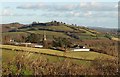
Landscove from the west
A view of Image and the adjoining school from Staverton Bridleway 16, looking over a Devon bank. Beyond is Image, with Beacon Hill to the left.
Image: © Derek Harper
Taken: 5 Dec 2008
0.03 miles
5
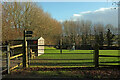
Cricket ground, Landscove
Across the lane from the school.
Image: © Derek Harper
Taken: 20 Dec 2020
0.03 miles
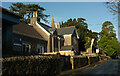
6
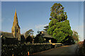
Church and lych-gate, Landscove
The lych-gate is listed and described at https://historicengland.org.uk/listing/the-list/list-entry/1147432 , St Matthew's church (by John Loughborough Pearson) at https://historicengland.org.uk/listing/the-list/list-entry/1108532 .
Image: © Derek Harper
Taken: 20 Dec 2020
0.03 miles
7
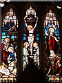
St Matthew's church - East window detail
Image: © Ruth Sharville
Taken: 24 May 2009
0.04 miles
8
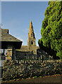
St Matthew's church, Landscove
St Matthew's church (architect John Loughborough Pearson) is listed and described at https://historicengland.org.uk/listing/the-list/list-entry/1108532 . Also listed is the lych gate https://historicengland.org.uk/listing/the-list/list-entry/1147432 on the left.
Image: © Derek Harper
Taken: 20 Dec 2020
0.04 miles
9
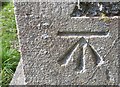
Ordnance Survey Cut Mark
This OS cut mark can be found on the NE face of St Matthew's Church. It marks a point 74.795m above mean sea level.
Image: © Adrian Dust
Taken: 26 Apr 2016
0.04 miles
10
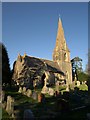
St Matthew's church, Landscove
Another view of Image, this time from the churchyard.
Image: © Derek Harper
Taken: 5 Dec 2008
0.04 miles