IMAGES TAKEN NEAR TO
Dolbeare, Ashburton, NEWTON ABBOT, TQ13 7LB
Introduction
This page details the photographs taken nearby to TQ13 7LB by members of the Geograph project.
The Geograph project started in 2005 with the aim of publishing, organising and preserving representative images for every square kilometre of Great Britain, Ireland and the Isle of Man.

There are currently over 7.5m images from over14,400 individuals and you can help contribute to the project by visiting https://www.geograph.org.uk
Image Map
Images are licensed for reuse under creativecommons.org/licenses/by-sa/2.0
Notes
- Clicking on the map will re-center to the selected point.
- The higher the marker number, the further away the image location is from the centre of the postcode.
Image Listing (26 Images Found)
Images are licensed for reuse under creativecommons.org/licenses/by-sa/2.0
Image
Details
Distance
1
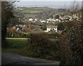
Towards Ashburton from Pitley Cross
Pitley Road drops towards Ashburton past a gateway giving a view over Dolbeare Farm (left) and Buckland View House. Behind are the eastern suburbs of the town, with Bowden Hill in the background.
Image: © Derek Harper
Taken: 10 Mar 2009
0.02 miles
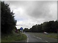
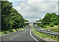
3
The A38, Devon Expressway, near Ashburton
Image: © Roger Cornfoot
Taken: 3 Dec 2008
0.07 miles

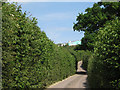
7
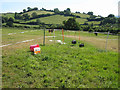
Electric fences forming paddocks
North of Pitley Farm, by the Dolbeare Road, with the slopes of Whistley Hill in the background.
Image: © Robin Stott
Taken: 22 Jun 2010
0.12 miles
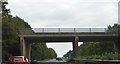
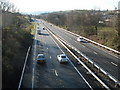
10
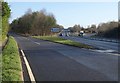
Junction on A38, Ashburton
The slip road leads into the northeastern end of Ashburton; the B3352 is actually the current number of the former main road through the centre of the town. Meanwhile, the expressway sweeps up a long hill to Caton Cross.
Image: © Derek Harper
Taken: 9 Mar 2009
0.14 miles