IMAGES TAKEN NEAR TO
Love Lane, NEWTON ABBOT, TQ13 7FJ
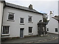
Introduction
This page details the photographs taken nearby to Love Lane, TQ13 7FJ by members of the Geograph project.
The Geograph project started in 2005 with the aim of publishing, organising and preserving representative images for every square kilometre of Great Britain, Ireland and the Isle of Man.

There are currently over 7.5m images from over14,400 individuals and you can help contribute to the project by visiting https://www.geograph.org.uk
Image Map
Images are licensed for reuse under creativecommons.org/licenses/by-sa/2.0
Notes
- Clicking on the map will re-center to the selected point.
- The higher the marker number, the further away the image location is from the centre of the postcode.
Image Listing (216 Images Found)
Images are licensed for reuse under creativecommons.org/licenses/by-sa/2.0
Image
Details
Distance
1
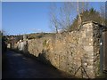
Love Lane, Ashburton
Taken at the point where a footpath from Hares Lane becomes a motorable road, between walls, heading for Whistley Hill. Ashburton's two church towers can be seen above the wall.
Image: © Derek Harper
Taken: 9 Mar 2009
0.03 miles
2
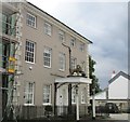
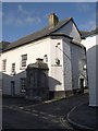
The Golden Lion, Ashburton
Eighteenth century private house, long since a hotel https://historicengland.org.uk/listing/the-list/list-entry/1282884
Image: © Jonathan Thacker
Taken: 16 Sep 2017
0.05 miles
3
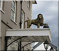
The Golden Lion
Stands on the roof of the porch of the Golden Lion Hotel.
Image: © Jonathan Thacker
Taken: 16 Sep 2017
0.05 miles
4
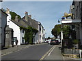
East Street, Ashburton
That looks like a conduit head or similar water source on the left.
Image: © Chris Allen
Taken: 17 Jul 2017
0.05 miles
5
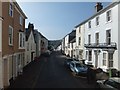
East Street with fine ironwork and bay windows
Image: © David Smith
Taken: 29 Feb 2012
0.05 miles
6
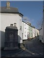
Conduit head, East Street, Ashburton
See Image for a similar photo looking up the lane on the right. The conduit head dates from 1791 and is described at http://www.imagesofengland.org.uk/details/default.aspx?id=376047 . The building behind is "believed to have been The Spread Eagle Inn" and extended to the left across what are now four separate properties - see http://www.imagesofengland.org.uk/Details/Default.aspx?id=376046&mode=adv .
Image: © Derek Harper
Taken: 9 Mar 2009
0.06 miles
7
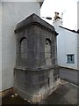
Conduit head in East Street, Ashburton
Presumably this was once a public water fountain, although there is no inscription. It is listed as a grade 2 water conduit
Image: © David Smith
Taken: 3 Oct 2012
0.06 miles
8
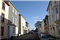
East Street, Ashburton
The street levels out after a steady climb from the town centre, but the impressive architecture continues, now from the C19. Beyond the slate-hung number 77 on the left (http://www.imagesofengland.org.uk/Details/Default.aspx?id=376054&mode=adv ) is the Ashburton Hotel http://www.imagesofengland.org.uk/details/default.aspx?id=376056 with a missing central first floor window.
On the immediate right is the Tugela House Hotel with canted bays on the first floor http://www.imagesofengland.org.uk/Details/Default.aspx?id=376048&mode=adv and then the three bays of a low former coach house and stables http://www.imagesofengland.org.uk/Details/Default.aspx?id=376050&mode=adv dated 1894.
Image: © Derek Harper
Taken: 9 Mar 2009
0.06 miles
9
House with conduit head, East Street
The conduit head dates from the early eighteenth century https://historicengland.org.uk/listing/the-list/list-entry/1187278
Image: © Jonathan Thacker
Taken: 16 Sep 2017
0.06 miles
10
Roborough Lane, Ashburton
Seen from across East Street. The lane leads up towards Image Contrast heavily reduced in this image to reveal something of the water conduit head on the left - see http://www.imagesofengland.org.uk/details/default.aspx?id=376047 . It dates from 1791.
Image: © Derek Harper
Taken: 9 Mar 2009
0.06 miles