IMAGES TAKEN NEAR TO
Ashburton Down, Ashburton, NEWTON ABBOT, TQ13 7EZ
Introduction
This page details the photographs taken nearby to TQ13 7EZ by members of the Geograph project.
The Geograph project started in 2005 with the aim of publishing, organising and preserving representative images for every square kilometre of Great Britain, Ireland and the Isle of Man.

There are currently over 7.5m images from over14,400 individuals and you can help contribute to the project by visiting https://www.geograph.org.uk
Image Map
Images are licensed for reuse under creativecommons.org/licenses/by-sa/2.0
Notes
- Clicking on the map will re-center to the selected point.
- The higher the marker number, the further away the image location is from the centre of the postcode.
Image Listing (6 Images Found)
Images are licensed for reuse under creativecommons.org/licenses/by-sa/2.0
Image
Details
Distance
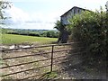
3
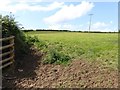
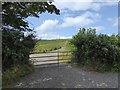
Field with one electricity pole
The power lines for the local farms do not follow the road, but cut across the fields
Image: © David Smith
Taken: 6 Aug 2014
0.14 miles
4
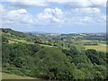
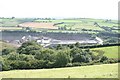
Woodland and gently rolling hills north of Ashburton
Seen from close to Brownswell on Roborough Lane, looking east
Image: © David Smith
Taken: 6 Aug 2014
0.16 miles
6
A plantation of young Christmas trees
A field on the north of Woodencliff Wood has been planted with Christmas trees
Image: © David Smith
Taken: 6 Aug 2014
0.24 miles