IMAGES TAKEN NEAR TO
Place Lane, NEWTON ABBOT, TQ13 7EP
Introduction
This page details the photographs taken nearby to Place Lane, TQ13 7EP by members of the Geograph project.
The Geograph project started in 2005 with the aim of publishing, organising and preserving representative images for every square kilometre of Great Britain, Ireland and the Isle of Man.

There are currently over 7.5m images from over14,400 individuals and you can help contribute to the project by visiting https://www.geograph.org.uk
Image Map
Images are licensed for reuse under creativecommons.org/licenses/by-sa/2.0
Notes
- Clicking on the map will re-center to the selected point.
- The higher the marker number, the further away the image location is from the centre of the postcode.
Image Listing (14 Images Found)
Images are licensed for reuse under creativecommons.org/licenses/by-sa/2.0
Image
Details
Distance
3

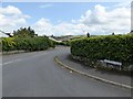
Lane to Ashburton
Further down the lane shown in Image
Image: © Derek Harper
Taken: 7 Aug 2019
0.15 miles

6
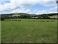
Cattle on the edge of Ashburton, and wooded hills
The land is rising towards the southern edge of Dartmoor; the buildings are farm buildings at Cuddyford Cross
Image: © David Smith
Taken: 6 Aug 2014
0.16 miles
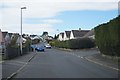
7
Balland Park, Ashburton
A road into a 20th century housing estate with a view to the hills beyond the A38
Image: © David Smith
Taken: 6 Aug 2014
0.16 miles
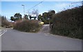
8
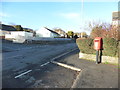
Letter box on Balland Lane, Ashburton
Image: © Ruth Sharville
Taken: 8 Mar 2015
0.17 miles
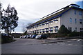
9
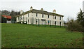
Place House
Listed and described at https://historicengland.org.uk/listing/the-list/list-entry/1280214 , this is now the sixth form centre for South Dartmoor Community College. Seen from Ashburton footpath 16.
Image: © Derek Harper
Taken: 2 Jan 2021
0.18 miles
10
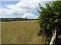
Grass field by Roborough Lane, north of Ashburton
Looking north-west through a gateway across the grass field with Woodencliff Woods beyond
Image: © David Smith
Taken: 6 Aug 2014
0.19 miles