IMAGES TAKEN NEAR TO
West Street, NEWTON ABBOT, TQ13 7DZ
Introduction
This page details the photographs taken nearby to West Street, TQ13 7DZ by members of the Geograph project.
The Geograph project started in 2005 with the aim of publishing, organising and preserving representative images for every square kilometre of Great Britain, Ireland and the Isle of Man.

There are currently over 7.5m images from over14,400 individuals and you can help contribute to the project by visiting https://www.geograph.org.uk
Image Map
Images are licensed for reuse under creativecommons.org/licenses/by-sa/2.0
Notes
- Clicking on the map will re-center to the selected point.
- The higher the marker number, the further away the image location is from the centre of the postcode.
Image Listing (223 Images Found)
Images are licensed for reuse under creativecommons.org/licenses/by-sa/2.0
Image
Details
Distance
1
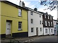
Houses on West Street, Ashburton
Most of the houses on this side of West Street are listed and date from the eighteenth and early nineteenth centuries. The house on the right has wooden shingles which probably hide timber framing https://historicengland.org.uk/listing/the-list/list-entry/1201036 The white house has a conduit head located at the right of the front wall https://historicengland.org.uk/listing/the-list/list-entry/1282867
Image: © Jonathan Thacker
Taken: 16 Sep 2017
0.04 miles
2

St. Andrew's House
Former Vicarage now Residential Care Home.
Image: © Jonathan Thacker
Taken: 16 Sep 2017
0.04 miles
3
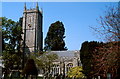
Ashburton, St Andrew's church
This church was entirely rebuilt in the 15th century, with its 92 ft tower.
Image: © Patrick GUEULLE
Taken: Unknown
0.05 miles
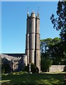
6
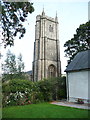
Tower of St Andrew's Church, Ashburton
Image: © Humphrey Bolton
Taken: 20 Sep 2013
0.06 miles
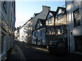
7
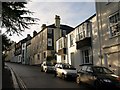
West Street, Ashburton (2)
A view further up Image, with sunlight filtered by trees in the northwest corner of the churchyard.
Image: © Derek Harper
Taken: 12 Dec 2008
0.06 miles
8
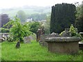
Churchyard, St Andrew's Church, Ashburton
The churchyard is extensive and commands wonderful views of the surrounding countryside.
Image: © Maigheach-gheal
Taken: 13 May 2009
0.07 miles
9

Poppies, St Andrew's Churchyard, Ashburton
In the language of flowers the yellow poppy means wealth and success.
Image: © Maigheach-gheal
Taken: 13 May 2009
0.07 miles
10
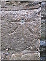
Ordnance Survey Bolt
This OS Bolt can be found on St Andrew's Church. It marks a point 75.291m above mean sea level.
Image: © Adrian Dust
Taken: 7 Apr 2014
0.07 miles