IMAGES TAKEN NEAR TO
Home Park, NEWTON ABBOT, TQ13 7BE
Introduction
This page details the photographs taken nearby to Home Park, TQ13 7BE by members of the Geograph project.
The Geograph project started in 2005 with the aim of publishing, organising and preserving representative images for every square kilometre of Great Britain, Ireland and the Isle of Man.

There are currently over 7.5m images from over14,400 individuals and you can help contribute to the project by visiting https://www.geograph.org.uk
Image Map
Images are licensed for reuse under creativecommons.org/licenses/by-sa/2.0
Notes
- Clicking on the map will re-center to the selected point.
- The higher the marker number, the further away the image location is from the centre of the postcode.
Image Listing (55 Images Found)
Images are licensed for reuse under creativecommons.org/licenses/by-sa/2.0
Image
Details
Distance
1
Catholic Church of Our Lady of Lourdes and St. Petroc
In East Street, Ashburton.
Image: © Roger Cornfoot
Taken: 3 Dec 2008
0.06 miles
2
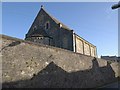
Catholic Church of Our Lady of Lourdes and St. Petroc, Ashburton
The small church, which dates from 1935, straddles a gridline. This rather unsatisfactory view of the western end and southern side is seen from Dolbeare Road.
Image: © Derek Harper
Taken: 9 Mar 2009
0.07 miles
3
Catholic church of Our Lady of Lourdes and St Petroc, Ashburton
Image: © Ruth Sharville
Taken: 14 Sep 2014
0.07 miles
4
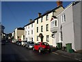
East Street, Ashburton
This is the start of East Street approaching the town centre from Exeter, at the junction with Dolbeare Road. The two three-storey houses on the right are fully described at http://www.imagesofengland.org.uk/Details/Default.aspx?id=376060&mode=adv and http://www.imagesofengland.org.uk/Details/Default.aspx?id=376061&mode=adv . Most of the buildings on East Street are listed.
Image: © Derek Harper
Taken: 9 Mar 2009
0.08 miles
5
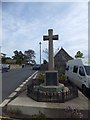
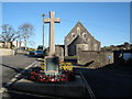
War memorial in Ashburton
Behind the memorial is the Roman Catholic church
Image: © David Smith
Taken: 3 Oct 2012
0.08 miles
6
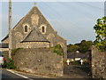
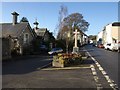
Mounting block outside RC church in Ashburton
The elaborate block is outside the Roman Catholic church
Image: © David Smith
Taken: 3 Oct 2012
0.08 miles
7
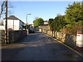
Dolbeare Road, Ashburton
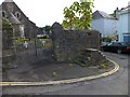
Dolbeare Road, which forks off the main street leading eastwards out of Ashburton at Image is seen here looking back towards the town. It has been truncated by the A38 expressway, but continues as a country lane (inaccessible from this point) on the other side.
Image: © Derek Harper
Taken: 9 Mar 2009
0.08 miles
8
Junction of Dolbeare Road with East Street, Ashburton
The cross is a war memorial. On the left are the nineteenth-century Coach House and The Wilderness http://www.imagesofengland.org.uk/Details/Default.aspx?id=376062&mode=adv , probably formerly stables associated with Ireland House, which is the first building on the other side of East Street.
Image: © Derek Harper
Taken: 9 Mar 2009
0.08 miles
9
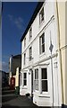
85 East Street, Ashburton
The C19 house with its dainty cornices and pilasters is shown in Image and described at http://www.imagesofengland.org.uk/Details/Default.aspx?id=376060&mode=adv . Along the street is Image
Image: © Derek Harper
Taken: 9 Mar 2009
0.08 miles
10
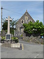
War memorial and place of worship, Ashburton
Image: © Chris Allen
Taken: 17 Jul 2017
0.09 miles