IMAGES TAKEN NEAR TO
Chudleigh, NEWTON ABBOT, TQ13 0NE
Introduction
This page details the photographs taken nearby to TQ13 0NE by members of the Geograph project.
The Geograph project started in 2005 with the aim of publishing, organising and preserving representative images for every square kilometre of Great Britain, Ireland and the Isle of Man.

There are currently over 7.5m images from over14,400 individuals and you can help contribute to the project by visiting https://www.geograph.org.uk
Image Map
Images are licensed for reuse under creativecommons.org/licenses/by-sa/2.0
Notes
- Clicking on the map will re-center to the selected point.
- The higher the marker number, the further away the image location is from the centre of the postcode.
Image Listing (30 Images Found)
Images are licensed for reuse under creativecommons.org/licenses/by-sa/2.0
Image
Details
Distance
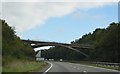
4
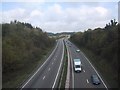
A38 near Chudleigh
Taken from Woodway Street north of the town. The dual carriageway is in the middle of a long climb away from the Teign valley.
Image: © Derek Harper
Taken: 16 Mar 2009
0.09 miles
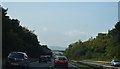
6
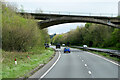
Bridge over the Devon Expressway near Chudleigh
Image: © David Dixon
Taken: 15 Apr 2022
0.10 miles
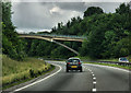
7
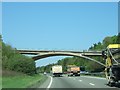
Woodway Street bridge over A38 north of Chudleigh
The design of the bridge is very similar to Image] which is about 1km to the east.
Image: © David Smith
Taken: 21 Apr 2011
0.10 miles

10
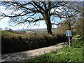
Start of the lane to Chudleighwoods Farm
Image: © David Gearing
Taken: 23 Apr 2013
0.11 miles