IMAGES TAKEN NEAR TO
Chudleigh Knighton, Chudleigh, NEWTON ABBOT, TQ13 0HS
Introduction
This page details the photographs taken nearby to TQ13 0HS by members of the Geograph project.
The Geograph project started in 2005 with the aim of publishing, organising and preserving representative images for every square kilometre of Great Britain, Ireland and the Isle of Man.

There are currently over 7.5m images from over14,400 individuals and you can help contribute to the project by visiting https://www.geograph.org.uk
Image Map
Images are licensed for reuse under creativecommons.org/licenses/by-sa/2.0
Notes
- Clicking on the map will re-center to the selected point.
- The higher the marker number, the further away the image location is from the centre of the postcode.
Image Listing (6 Images Found)
Images are licensed for reuse under creativecommons.org/licenses/by-sa/2.0
Image
Details
Distance
1
Trees and hedges by the road past Warwicks
The trees screen and shelter the farm, part of which is visible up the hill
Image: © David Smith
Taken: 12 Jul 2013
0.03 miles
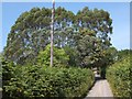
2

Lane near Chudleigh Knighton
Looking almost north up this lane climbing away from the Bovey basin.
Image: © Derek Harper
Taken: 13 Apr 2006
0.05 miles
3
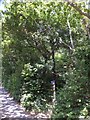
Private woodlands near Warwicks
An open gate and well-trodden path by the side of the road, with a sign by the gate declaring it to be private woodland
Image: © David Smith
Taken: 12 Jul 2013
0.07 miles
4
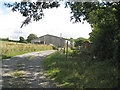
Barn by the track to Culverhouse Combe
Enjoying the sound of the chickens, I sat down near the gate to have a drink and look at the map. A smartly-dressed man on horseback appeared from the lane behind the camera. He looked me up and down, we exchanged "Good mornings" and he rode back up the lane.
Image: © Robin Stott
Taken: 24 Aug 2011
0.10 miles
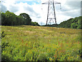
5
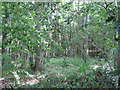
Down's Plantations
A view into the woodland on the summit north of the house called Warwicks.
Image: © Robin Stott
Taken: 24 Aug 2011
0.12 miles